Buritizeiro, Minas Gerais
Waterfalls and rapids of the São Francisco · Northern Minas
Buritizeiro lies on the left bank of the Rio São Francisco, facing Pirapora. The name comes from the abundance of buriti palms in the region. It is one of the largest towns in Minas by area, in cerrado country. The economy revolves around farming, ranching, fishing and tourism. The waterfalls and the rapids of the São Francisco are the main attractions.
Buritizeiro at a glance
- Population: 24 thousand
- Area: 7.218 km²
- Elevation: 500 m
- Distance from Belo Horizonte: 365 km
- Demonym: buritizeirense
- Founded: 1962
- Region: North and Northwest
- Tourism region: IGR Guimarães Rosa
- Area code: 38
- IBGE code: 3109402
Buritizeiro is part of the tourism region IGR Guimarães Rosa.
History
The bandeirantes Soeiros and Salmeron reached the region by the Rio das Velhas and then by the São Francisco, as far as the Pirapora falls. With them came mostly fishermen. Two villages formed: Pirapora, on the right bank, and São Francisco de Pirapora, on the left bank.
Settlement met resistance from the Cariri Indigenous people. Plentiful fishing attracted new residents, who sold fish to drovers and travelers.
The district of São Francisco de Pirapora was created in 1861, in the municipality of São Francisco. In 1911 it passed to Pirapora. In 1923 it was named Buritizeiro, at the suggestion of Francisco Ribeiro da Cruz, because of the many buriti palms in the region.
On December 30, 1962, State Law No. 2,764 created the municipality of Buritizeiro, separate from Pirapora. It was formally established on March 1, 1963.
Timeline
- 1861 · District of São Francisco de Pirapora created
- 1911 · The district passes to the municipality of Pirapora
- 1923 · The district is named Buritizeiro
- 1957 · Comitê Pró-melhoramento de Buritizeiro founded
- 1962 · Municipality created by State Law No. 2,764
- 1963 · Municipality established, on March 1
- 1997 · District of Sambaíba de Minas created
Things to do in Buritizeiro: attractions
Corredeiras do São Francisco
Nature · Next to the Marechal Hermes Bridge, between Buritizeiro and Pirapora
A stretch of rapids about 600 m long starting at the Ponte Marechal Hermes. It draws anglers from all over the country.
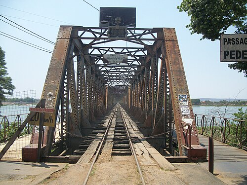
Ponte Marechal Hermes
Historic bridge · Rio São Francisco
Railroad bridge over the São Francisco linking Buritizeiro to Pirapora. Construction began in 1920.
Cachoeira Grande
Waterfall · Fazenda Santa Cruz
One of the best-known waterfalls in the town.
Cachoeira do Córrego da Areia
Waterfall · Fazenda dos Cristais
Waterfall on farmland.
Cachoeira do Riacho Doce
Waterfall · Fazenda dos Cristais
Waterfall on farmland.
Cachoeira das Andorinhas
Waterfall
One of the waterfalls listed among the town's attractions.
Cachoeira do Córrego do Gentil
Waterfall
One of the waterfalls listed among the town's attractions.
Caixa d'água archaeological site
Archaeological site
Site identified in 1975 and rediscovered in 1987, during construction work.
Heritage
- Antiga Escola de Aprendizes Marinheiros · Eclectic-style complex listed by the state in 2018, linked to navigation on the Rio São Francisco. It also housed a regional hospital and an educational center.
Nature
- Cerrado · Vegetation mixing pastures and small woodlands, with fruits such as pequi, umbu and cashew
- Rio São Francisco · The town stretches for more than 300 km along the river's left bank
Rivers and waters
- River basin: Rio São Francisco
- Rivers: Rio São Francisco
Climate
- Type: Central Brazil tropical, hot, semi-humid (4 to 5 dry months)
- Winter: Average temperature above 18 °C in every month.
Typical food
- Cerrado sweets and liqueurs · Cerrado sweets and liqueurs: a local project makes sweets, jams and liqueurs from regional fruits
- São Francisco river fish · São Francisco fish: fishing is an old tradition in the region
Festivals and events
- June Festivals (jun) · Seasonal festivities organized with community support
Fun facts
- The name comes from the buriti palm, abundant in the region.
- It is the 5th largest town in Minas Gerais by area.
- The Escola Caio Martins, founded in the early 1950s, honors a boy scout who died in the Serra da Canastra.
- The bridge and railroad that pass through the town were part of an unfinished plan to link Rio de Janeiro to Belém do Pará.
Getting there
- Belo Horizonte · About 365 km
- Pirapora · 6 km, via the Ponte Marechal Hermes
- Montes Claros · About 167 km
Districts
- Cachoeira do Manteiga
- Paredão de Minas
- Sambaíba de Minas
Notable people from Buritizeiro
- Francisco Ribeiro da Cruz · Suggested the name Buritizeiro and chaired the Comitê Pró-melhoramento, founded in 1957
People born in Buritizeiro
- Wisrah C. V. da R. Celestino · Artista, artista visual · b. 1989
City hall
- Mayor: Marcelo Pereira Osório (Marcelo Osório), term 2025–2028
- Address: Praça Coronel José Geraldo, 01, Centro, Buritizeiro, MG, CEP 39280-000
- Phone: (38) 3742-1011
- Website: www.buritizeiro.mg.gov.br
Frequently asked questions
Where is Buritizeiro?
Buritizeiro is a municipality in the state of Minas Gerais, Brazil, in the North and Northwest region, 365 km from Belo Horizonte.
What is there to do in Buritizeiro?
The attractions of Buritizeiro include Corredeiras do São Francisco, Ponte Marechal Hermes, Cachoeira Grande, Cachoeira do Córrego da Areia, Cachoeira do Riacho Doce, Cachoeira das Andorinhas.
What is the population of Buritizeiro?
Buritizeiro has about 24 thousand inhabitants in an area of 7.218 km².
What is the typical food of Buritizeiro?
Doces e licores do cerrado (Cerrado sweets and liqueurs: a local project makes sweets, jams and liqueurs from regional fruits); Peixe do São Francisco (São Francisco fish: fishing is an old tradition in the region).
How do you get to Buritizeiro?
Belo Horizonte: About 365 km. Pirapora: 6 km, via the Ponte Marechal Hermes. Montes Claros: About 167 km.
Who was born in Buritizeiro?
Notable people from Buritizeiro include Francisco Ribeiro da Cruz, Wisrah C. V. da R. Celestino (artist, visual artist).
Which tourism region is Buritizeiro part of?
Buritizeiro is part of IGR Guimarães Rosa, one of the 47 official tourism regions of Minas Gerais, with 12 municipalities.
What are the festivals of Buritizeiro?
June Festivals (jun).
What are people from Buritizeiro called?
People born in Buritizeiro are called buritizeirense.
Towns near Buritizeiro
- Pirapora · 4 km in a straight line
- Várzea da Palma · 36 km in a straight line
- Ibiaí · 57 km in a straight line
- Jequitaí · 58 km in a straight line
- Lagoa dos Patos · 59 km in a straight line
- Lassance · 71 km in a straight line
- Francisco Dumont · 78 km in a straight line
- Ponto Chique · 83 km in a straight line