Jaboticatubas, Minas Gerais
Gateway to Serra do Cipó · Belo Horizonte Metropolitan Region
Jaboticatubas lies in the Belo Horizonte Metropolitan Region, in the Serra do Espinhaço range. About 80% of its territory is inside Parque Nacional da Serra do Cipó. The town grew up along the old Estrada do Serro, on 18th-century farms. Highlights include the district of São José da Serra, the Rota dos Sete Rios, the natural pools of the Rio Bom Jardim and the Cânion das Bandeirinhas.
Jaboticatubas at a glance
- Population: 20 thousand
- Area: 1.115 km²
- Elevation: 739 m
- Distance from Belo Horizonte: 66 km
- Demonym: jaboticatubense
- Founded: 1938
- Region: Greater BH and Central
- Tourism region: IGR Serra do Cipó
- Area code: 31
- IBGE code: 3134608
Jaboticatubas is part of the tourism region IGR Serra do Cipó.
History
The region was settled along the Estrada do Serro, which connected the mining towns. In 1714, founding members of the Convento de Macaúbas occupied land along the road.
By around 1750 there were already farms such as Bamburral, Costas, Ribeirão and Minhocas. In 1753, Captain Manoel Gomes da Mota asked the Diocese of Mariana for permission to build a chapel near the Fazenda do Ribeirão.
After 1753, Antônio Raposo de Oliveira bought the farm, and for several years the settlement was called Ribeirão do Raposo. The current name comes from the stream that runs through the town. The main reference work on local history is História de Jaboticatubas, by Leonidas Marques Afonso, published in 1957.
Timeline
- 1714 · Members of the Convento de Macaúbas occupy land along the Estrada do Serro
- 1750 · Bamburral, Costas, Ribeirão and Minhocas farms already established (approximate date)
- 1753 · Request for permission to build a chapel near the Fazenda do Ribeirão
- 1957 · Publication of História de Jaboticatubas, by Leonidas Marques Afonso
Things to do in Jaboticatubas: attractions
Parque Nacional da Serra do Cipó
Nature
The park covers about 80% of the municipality, with waterfalls, rapids, canyons and rocky highland grasslands.
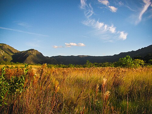
Cânion das Bandeirinhas
Nature · Parque Nacional da Serra do Cipó
A canyon with a route of about 12 km, one of the symbols of Serra do Cipó.
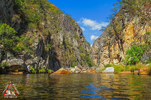
São José da Serra
District · District of Jaboticatubas
A tourism hub near Serra do Cipó, with waterfalls and restaurants.
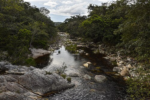
Rota dos Sete Rios
Nature · Ribeirão Vermelho
A dirt-road route along the Ribeirão Vermelho, with stops at the river bends and bamboo walkways.
Natural pools of the Bom Jardim River
Nature · Rio Bom Jardim
Natural swimming holes and pools, listed among the town's attractions.
Cachoeiras da Serra da Contagem e da Serra do Bené
Waterfall
Waterfalls in the municipality's mountain ranges.
Quedas do Rio Jaboticatubas
Waterfall · São José da Serra
Waterfalls on the river that gives the town its name, in São José da Serra.
Restaurante da Cristina
Food · São José da Serra
A restaurant serving Minas Gerais home cooking in a mid-19th-century building, with a cross dated 1802 on the grounds.
Heritage
- Igreja Nossa Senhora do Rosário · Chapel built around 1880 by Father Messias Marques Afonso. Listed by the municipality in the 1990 Organic Law.
- Conjunto da Igreja Matriz e Praça das Castanheiras · Igreja Matriz de Nossa Senhora da Conceição and a square with chestnut trees. Listed by the municipality by Decree no. 627/2006.
- Conjunto Arquitetônico da Fazenda do Cipó · Main house, slave quarters and chapel in colonial style, near km 95 of MG-10. Listed by the municipality in the 1990 Organic Law.
- Fazenda das Minhocas e Engenhos · Farm listed by the municipality by Decree no. 602/2006.
- Image of São José de Botas · Statue kept in the Igreja do Rosário. Listed by the municipality by Decree no. 627/2006.
- Feast of São João do Mato do Tição · Registered by the municipality as a celebration by Decree no. 1094/2010.
- Folias de Reis (Epiphany processions) · Groups such as the Folia de Reis São José da Serra are part of the Folias de Minas, registered by IEPHA in 2017.
Nature
- Parque Nacional da Serra do Cipó · About 80% of the municipality's territory
- Reserva da Biosfera da Serra do Espinhaço · UNESCO recognition for the entire range
Rivers and waters
- River basin: Rio São Francisco
- Rivers: Ribeirão Vermelho, Rio Bom Jardim, Rio Jaboticatubas
- Springs: The region holds springs of tributaries of the São Francisco and Doce rivers.
Climate
- Type: Central Brazil tropical, subwarm, semi-humid (4 to 5 dry months)
- Winter: At least one month averages between 15 and 18 °C.
- Best time to visit: Dry season, April to September, according to Serra do Cipó guides
Typical food
- Tropeirão · A Minas Gerais dish (beans with manioc flour, pork and eggs) served at the restaurants of São José da Serra
- Chicken with okra · The best-known dish at Restaurante da Cristina
- Copa-lombo · An item of Minas Gerais cuisine (cured pork loin) served in the region
Festivals and events
- Folia de Reis (Jan) · Groups visit nativity scenes and rural communities. Since 2025 there has been a gathering of folias at the Centro Cultural.
- Carnival (Fev) · Parades of more than ten street bands on Praça Nossa Senhora da Conceição, with the Bateria Integração and the Banda Mole.
- Festa dos Mascarados (Bando do Judas) · On Easter Sunday, a parade and burning of the Judas and Sabina effigies, with the reading of their wills.
- Feast of São João do Mato do Tição (Jun) · On the night of June 23 to 24, the quilombola community performs rituals and walks over hot coals at midnight.
- Expo Jabó (Ago) · Concerts, rodeo, agricultural fair, horseback parade and the Queima do Alho at the Parque de Exposições Álvaro Teixeira Costa.
- Festas de Setembro (Set) · September Festivals: pilgrimage, the Festa de Nossa Senhora do Rosário with candombe and the Festa do Divino Espírito Santo with an imperial procession.
- Feast of Nossa Senhora da Conceição (Dez) · Patron saint festival on December 8, with novenas, a procession and a community lunch.
Fun facts
- The town was once called Ribeirão do Raposo.
- About 80% of its territory lies inside Parque Nacional da Serra do Cipó.
- Parque Nacional da Serra do Cipó was created in 1984 and also covers Santana do Riacho, Morro do Pilar and Itambé do Mato Dentro.
Getting there
- Belo Horizonte · About 66 km
Districts
- Almeida
- São José da Serra
Notable people from Jaboticatubas
- Padre Messias Marques Afonso · Born in Jaboticatubas and ordained in 1860. He renovated the mother church and built other chapels. He is considered the town's true founder.
- Capitão Manuel Gomes da Mota · Owner of the Fazenda do Ribeirão, he had the chapel of the Imaculada Conceição built in 1753, the origin of the village.
- Félix da Costa · The Ermitão da Caridade (Hermit of Charity), founder of the Mosteiro de Macaúbas, who acquired the region's land through sesmarias in the 18th century.
- Antônio Raposo de Oliveira · Inherited the Fazenda do Ribeirão. In 1841 the Curato do Ribeirão do Raposo was created.
People born in Jaboticatubas
City hall
- Mayor: Racly Araújo Andrade (Solidariedade), term 2025–2028
- Address: Praça N Senhora da Conceição, 38, Não Informado, Jaboticatubas, MG, CEP 35830-000
- Website: www.jaboticatubas.mg.gov.br
Frequently asked questions
Where is Jaboticatubas?
Jaboticatubas is a municipality in the state of Minas Gerais, Brazil, in the Greater BH and Central region, 66 km from Belo Horizonte.
What is there to do in Jaboticatubas?
The attractions of Jaboticatubas include Parque Nacional da Serra do Cipó, Cânion das Bandeirinhas, São José da Serra, Rota dos Sete Rios, Piscinas naturais do Rio Bom Jardim, Cachoeiras da Serra da Contagem e da Serra do Bené.
What is the population of Jaboticatubas?
Jaboticatubas has about 20 thousand inhabitants in an area of 1.115 km².
What is the typical food of Jaboticatubas?
Tropeirão (A Minas Gerais dish (beans with manioc flour, pork and eggs) served at the restaurants of São José da Serra); Frango com quiabo (The best-known dish at Restaurante da Cristina); Copa-lombo (An item of Minas Gerais cuisine (cured pork loin) served in the region).
When is the best time to visit Jaboticatubas?
Dry season, April to September, according to Serra do Cipó guides. The climate is central brazil tropical, subwarm, semi-humid (4 to 5 dry months).
How do you get to Jaboticatubas?
Belo Horizonte: About 66 km.
Who was born in Jaboticatubas?
Notable people from Jaboticatubas include Padre Messias Marques Afonso, Capitão Manuel Gomes da Mota, Félix da Costa, Antônio Raposo de Oliveira, Ramiro da Cartucheira.
Which tourism region is Jaboticatubas part of?
Jaboticatubas is part of IGR Serra do Cipó, one of the 47 official tourism regions of Minas Gerais, with 9 municipalities.
What are the festivals of Jaboticatubas?
Folia de Reis (Jan), Carnaval (Fev), Festa dos Mascarados (Bando do Judas), Festa de São João do Mato do Tição (Jun), Expo Jabó (Ago), Festas de Setembro (Set), Festa de Nossa Senhora da Conceição (Dez).
What are people from Jaboticatubas called?
People born in Jaboticatubas are called jaboticatubense.
Towns near Jaboticatubas
- Taquaraçu de Minas · 18 km in a straight line
- Lagoa Santa · 22 km in a straight line
- Nova União · 25 km in a straight line
- Vespasiano · 28 km in a straight line
- Santa Luzia · 29 km in a straight line
- Confins · 30 km in a straight line
- São José da Lapa · 31 km in a straight line
- Pedro Leopoldo · 34 km in a straight line