Lima Duarte, Minas Gerais
Gateway to Ibitipoca · Zona da Mata
Lima Duarte is in the Zona da Mata region, near the Serra da Mantiqueira, and is the gateway to the Parque Estadual do Ibitipoca. The park has quartzite caves, caramel-colored waterfalls and lookouts such as the Janela do Céu. In the district of Conceição do Ibitipoca, a village of stone streets is home to a mother church from 1768. The town was born from the search for gold in the Rio do Peixe at the end of the 17th century. In 2026, Conceição do Ibitipoca was one of Brazil's nominees for UN Tourism's Best Tourism Villages award.
Lima Duarte at a glance
- Population: 17,2 thousand
- Area: 848,6 km²
- Elevation: 860 m
- Distance from Belo Horizonte: 295 km
- Demonym: limaduartino
- Founded: 1881
- Region: Zona da Mata and Vertentes
- Tourism region: IGR Serras de Ibitipoca
- Area code: 32
- IBGE code: 3138609
Lima Duarte is part of the tourism region IGR Serras de Ibitipoca.
History
Around 1692, bandeirantes (colonial explorers) led by Father João Faria Filho reached the region and found gold in the Rio do Peixe. The discovery was reported to the colonial general government in Bahia in 1694. The first settlements along the river appeared around 1740.
In Ibitipoca, the Igreja Matriz de Nossa Senhora da Conceição was built in 1768, during the gold era. The Rio do Peixe settlement became a Distrito de Paz (justice-of-the-peace district) in 1839 and a parish in 1859.
In 1881 the town was created, split off from Barbacena. In 1884 it became a city, with its current name honoring José Rodrigues de Lima Duarte, a minister and senator of the Empire. The railway station opened in 1926, and the branch line was shut down in 1974.
The Parque Estadual do Ibitipoca was created on July 4, 1973, by a decree signed in Conceição do Ibitipoca. Since then, nature tourism has become one of the municipality's hallmarks.
Timeline
- 1692 · Bandeirantes find gold in the Rio do Peixe
- 1768 · Construction of the Matriz de Nossa Senhora da Conceição de Ibitipoca
- 1839 · The settlement becomes a Distrito de Paz
- 1859 · Creation of the Rio do Peixe parish
- 1881 · Creation of the town, split off from Barbacena
- 1884 · Elevated to city status under the name Lima Duarte
- 1926 · Opening of the railway station
- 1973 · Creation of the Parque Estadual do Ibitipoca
- 1989 · State heritage listing of the Serra do Ibitipoca
- 2026 · Conceição do Ibitipoca competes for UN Tourism's Best Tourism Villages award
Things to do in Lima Duarte: attractions
Parque Estadual do Ibitipoca
Nature · Conceição do Ibitipoca
A 1,488-hectare park created in 1973, with caves, waterfalls and rocky highland fields. Visits have a daily cap on the number of people.
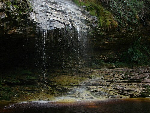
Janela do Céu
Waterfall · Parque Estadual do Ibitipoca
A natural lookout over a seven-tier waterfall, the park's most famous spot.
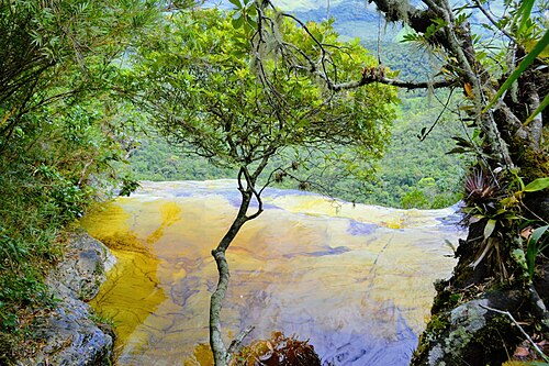
Gruta dos Viajantes
Cave · Parque Estadual do Ibitipoca
One of the park's quartzite caves, alongside the Martiniano and Moreiras caves.
Pico do Pião
Lookout · Parque Estadual do Ibitipoca
A peak with sweeping views of the mountains, one of the park's classic destinations.
Lago dos Espelhos
Nature · Parque Estadual do Ibitipoca
A pool of caramel-colored water inside the park.
Ponte de Pedra
Nature · Parque Estadual do Ibitipoca
A natural rock arch on the Paredão de Santo Antônio.
Vila de Conceição do Ibitipoca
Village · District of Conceição do Ibitipoca, a 25 km da sede
A village of stone streets with about a thousand residents, guesthouses, cachaça bars and restaurants.
Matriz de Nossa Senhora da Conceição
Church · Conceição do Ibitipoca
A Baroque church built in 1768, in the center of the village of Ibitipoca.
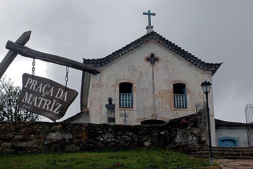
Canyon das Andorinhas
Nature · Lima Duarte
A canyon with walls up to 50 meters high, pools and waterfalls.
Igreja Nossa Senhora do Rosário
Church · Centro, Lima Duarte
A church in the town center designed by Carlos Baumgratz and inaugurated in 1988.
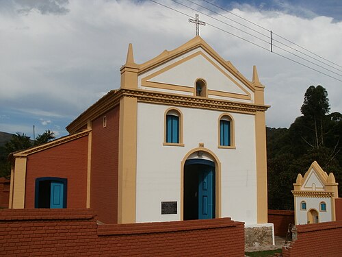
Heritage
- Serra do Ibitipoca · Listed as state heritage in 1989 and declared a natural monument, with the Pico da Lombada at 1,784 meters.
- Parque Estadual do Ibitipoca · A state conservation area created in 1973.
Nature
- Serra do Ibitipoca · A quartzite mountain range with caves, sinkholes and natural bridges.
- Rocky grasslands (campos rupestres) · Low vegetation growing on rock, with cacti, bromeliads and many endemic species.
- Caramel-colored waters · The park's rivers are dark because of organic matter.
- Pico da Lombada · The highest point in the municipality, at 1,784 meters.
Rivers and waters
- River basin: Paraíba do Sul River Basin
- Rivers: Rio do Peixe, Rio do Salto, Rio Grão-Mogol
- Springs: The Salto River rises inside Ibitipoca State Park, and the Grão-Mogol River rises on the park's boundaries.
Climate
- Type: Tropical highland (Cwb)
- Winter: Dry and cold, with June as the coldest month and July as the driest.
- Summer: Hot and rainy, with December as the rainiest month.
Typical food
- Feijão tropeiro (drover's beans) · Typical Minas dish (beans with manioc flour, bacon and sausage) served in the region.
- Rolled pork crackling · Rolled pork crackling, a snack served in the bars of Conceição do Ibitipoca.
- Angu pastry · Traditional savory pastry in the village restaurants.
- Cinnamon bread · Cinnamon bread, a well-known baked treat in Ibitipoca.
- Artisanal cachaça · Sold in the village's small bars.
- Artisanal Minas Cheese (Ibitipoca mountains region) · Lima Duarte is part of the Serras da Ibitipoca region, recognized by IMA as a producer of this cheese (IMA Ordinance no. 2016).
Festivals and events
- IbitiReggae (Apr) · A reggae festival in the Ibitipoca area.
- Feast of Santo Antônio de Ibitipoca (Jun) · A traditional religious festival in the district.
- Deguste dos Sabores (Jul) · The town's food festival.
- Encontro de Cavaleiros (Aug) · A gathering of horseback riders and riding groups.
- Agricultural Fair (Sep) · An agricultural and livestock fair held around the town's anniversary.
Fun facts
- The old railway branch line, shut down in 1974, became a rural road used by cyclists.
- Ibitipoca comes from Indigenous terms related to stone and house, or broken mountain.
- The Minas Gerais state government cites the Parque do Ibitipoca as the most visited park in the state.
- In July 2001, no rainfall was recorded in the municipality.
Getting there
- Belo Horizonte · About 295 km
- Juiz de Fora · Airport about 70 km from downtown
- Conceição do Ibitipoca · 25 km from downtown Lima Duarte
Districts
- Conceição da Ibitipoca
- Manejo
- Orvalho
- São Domingos da Bocaina
- São José dos Lopes
Notable people from Lima Duarte
- José Rodrigues de Lima Duarte · Viscount, minister and senator of the Empire, after whom the town is named
- Padre João Faria Filho · Leader of the bandeirante expedition that found gold in the Rio do Peixe
- Bento Corrêa de Souza Coutinho · Reported the gold discovery to the general government
- Carlos Baumgratz · Architect of the Igreja Nossa Senhora do Rosário in the town seat
- Francisco Xavier Rodrigues Campelo · First judge of the judicial district
People born in Lima Duarte
- Iriny Nicolau Corres Lopes · Política do Brasil · b. 1956
- José Eugênio Corrêa
- José Guimarães Duque · Agronomist, Brazilian writer · 1903–1978
- Maurício Godinho Delgado
- Paulo Delgado · Brazilian politician
City hall
- Mayor: Elenice Pereira Delgado Santelli (PT), term 2025–2028
- Address: Rua Tancredo Alves, 57, Centro, Lima Duarte (MG), CEP 36140-000
- Phone: (32) 3281-1281
- Opening hours: Monday to Friday, 8:00 to 17:00
- Website: www.limaduarte.mg.gov.br
Frequently asked questions
Where is Lima Duarte?
Lima Duarte is a municipality in the state of Minas Gerais, Brazil, in the Zona da Mata and Vertentes region, 295 km from Belo Horizonte.
What is there to do in Lima Duarte?
The attractions of Lima Duarte include Parque Estadual do Ibitipoca, Janela do Céu, Gruta dos Viajantes, Pico do Pião, Lago dos Espelhos, Ponte de Pedra.
What is the population of Lima Duarte?
Lima Duarte has about 17,2 thousand inhabitants in an area of 848,6 km².
What is the typical food of Lima Duarte?
Feijão tropeiro (Typical Minas dish (beans with manioc flour, bacon and sausage) served in the region); Torresmo de rolo (Rolled pork crackling, a snack served in the bars of Conceição do Ibitipoca); Pastel de angu (Traditional savory pastry in the village restaurants); Pão de canela (Cinnamon bread, a well-known baked treat in Ibitipoca); Artisanal cachaça (Sold in the village's small bars); Queijo Minas Artesanal (Região Serras da Ibitipoca) (Lima Duarte is part of the Serras da Ibitipoca region, recognized by IMA as a producer of this cheese (IMA Ordinance no. 2016)).
How do you get to Lima Duarte?
Belo Horizonte: About 295 km. Juiz de Fora: Airport about 70 km from downtown. Conceição do Ibitipoca: 25 km from downtown Lima Duarte.
Who was born in Lima Duarte?
Notable people from Lima Duarte include José Rodrigues de Lima Duarte, Padre João Faria Filho, Bento Corrêa de Souza Coutinho, Carlos Baumgratz, Francisco Xavier Rodrigues Campelo, Iriny Nicolau Corres Lopes (politician of brazil), José Eugênio Corrêa, José Guimarães Duque (agronomist, brazilian writer).
Which tourism region is Lima Duarte part of?
Lima Duarte is part of IGR Serras de Ibitipoca, one of the 47 official tourism regions of Minas Gerais, with 11 municipalities.
What are the festivals of Lima Duarte?
IbitiReggae (Apr), Festa de Santo Antônio de Ibitipoca (Jun), Deguste dos Sabores (Jul), Encontro de Cavaleiros (Aug), Exposição Agropecuária (Sep).
What are people from Lima Duarte called?
People born in Lima Duarte are called limaduartino.
Towns near Lima Duarte
- Olaria · 15 km in a straight line
- Pedro Teixeira · 15 km in a straight line
- Santa Bárbara do Monte Verde · 16 km in a straight line
- Bias Fortes · 27 km in a straight line
- Rio Preto · 28 km in a straight line
- Santa Rita de Ibitipoca · 33 km in a straight line
- Belmiro Braga · 41 km in a straight line
- Santana do Garambéu · 42 km in a straight line