Bocaina de Minas, Minas Gerais
Headwaters of the Rio Grande · Serra da Mantiqueira
Bocaina de Minas lies in the Serra da Mantiqueira, in southern Minas, at an altitude of 1,210 m. Part of its territory is within the Parque Nacional do Itatiaia. The municipality is home to the headwaters of the Rio Grande, which feeds the Paraná basin. It has three districts and borders Itamonte, Alagoa and Aiuruoca.
Bocaina de Minas at a glance
- Population: 5,3 thousand
- Area: 502,7 km²
- Elevation: 1.210 m
- Distance from Belo Horizonte: 380 km
- Demonym: bocainense
- Founded: 1953
- Region: Zona da Mata and Vertentes
- Tourism region: IGR Terras Altas da Mantiqueira
- Area code: 32
- IBGE code: 3107208
Bocaina de Minas is part of the tourism region IGR Terras Altas da Mantiqueira.
History
Around 1790, according to local legend, two farmers decided to build a chapel. Since they could not agree on the location, they rode out on horseback from their homes and agreed to build the church wherever they met. The village grew up on that spot.
In 1858 the district of Rosário da Bocaina was created, linked to Aiuruoca. In 1892 the parish of Nossa Senhora do Rosário was established. In 1923 the district was renamed Bocaina and, in 1938, it was transferred to the new municipality of Liberdade. In 1943 it was given the name Arimatéia.
State Law No. 1,039, of December 12, 1953, created the municipality of Bocaina de Minas, separated from Liberdade. It was installed on January 1, 1954.
Timeline
- c. 1790 · Origin of the village, according to local tradition
- 1858 · District of Rosário da Bocaina created
- 1892 · Parish of Nossa Senhora do Rosário created
- 1923 · District is renamed Bocaina
- 1943 · Renamed Arimatéia; the district of Mirantão is created
- 1953 · Creation of the municipality of Bocaina de Minas
- 1954 · Installation of the municipality
- 2019 · District of Santo Antônio do Alto Rio Grande created
Things to do in Bocaina de Minas: attractions
Itatiaia National Park (part of the territory)
Nature
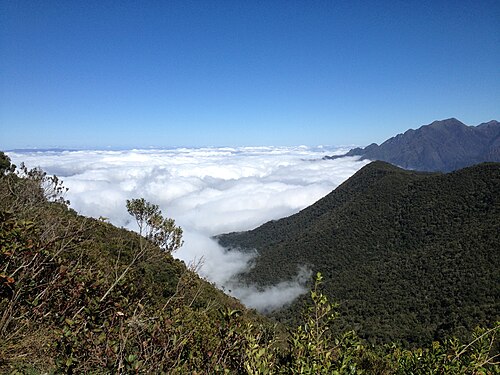
Part of the municipality lies within the park, in the Serra da Mantiqueira.
Sources of the Grande River
Nature
The municipality is home to the headwaters of the Rio Grande.
Igreja de Nossa Senhora do Rosário
Church
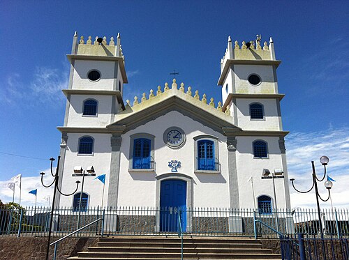
Mother church, rebuilt and enlarged in 1862, a date carved into the facade.
Nature
- Parque Nacional do Itatiaia · Part of the municipality's territory lies within the park.
- Sources of the Grande River · Source of the Paraná basin.
Rivers and waters
- River basin: Grande river basin (Paraná)
- Rivers: Rio Grande
- Springs: The municipality is home to the sources of the Grande River.
Climate
- Type: Central Brazil tropical, mild mesothermal, humid (3 dry months)
- Winter: Coldest month averages between 10 and 15 °C.
Typical food
- Queijo Artesanal Mantiqueira de Minas · Made in the town and in other Mantiqueira towns, with starter culture and heated curd, unlike traditional artisanal Minas cheese.
Festivals and events
- Festival Gastronômico · Municipal food festival, with its 4th edition regulated in 2024. The date has not been confirmed.
Fun facts
- It was once called Arimatéia, between 1943 and 1953.
- The municipality borders Aiuruoca, Alagoa, Carvalhos, Liberdade, Itamonte and Passa Vinte.
Getting there
- Belo Horizonte · 390 km via BR-040 and BR-267, passing through Liberdade
- Rio de Janeiro · Via BR-116 (Via Dutra) to Resende and then RJ-161; 296 km paved and 29 km of dirt road
Districts
- Mirantão
- Santo Antônio do Alto Rio Grande
Notable people from Bocaina de Minas
People born in Bocaina de Minas
- Joaquim Romério de Almeida · Político brasileiro · b. 1959
- Josemar Antonio Diniz · Político do Brasil · b. 1950
City hall
- Mayor: Luzimar de Moura Benfica (Progressistas), term 2025–2028
- Address: Rua Capitão João Mariano Dias, 86, Centro, Bocaina de Minas, MG, CEP 37340-000
- Opening hours: Monday to Friday, 8:00 to 16:00
- Website: www.bocainademinas.mg.gov.br
Frequently asked questions
Where is Bocaina de Minas?
Bocaina de Minas is a municipality in the state of Minas Gerais, Brazil, in the Zona da Mata and Vertentes region, 380 km from Belo Horizonte.
What is there to do in Bocaina de Minas?
The attractions of Bocaina de Minas include Parque Nacional do Itatiaia (parte do território), Nascentes do rio Grande, Igreja de Nossa Senhora do Rosário.
What is the population of Bocaina de Minas?
Bocaina de Minas has about 5,3 thousand inhabitants in an area of 502,7 km².
What is the typical food of Bocaina de Minas?
Queijo Artesanal Mantiqueira de Minas (Made in the town and in other Mantiqueira towns, with starter culture and heated curd, unlike traditional artisanal Minas cheese).
How do you get to Bocaina de Minas?
Belo Horizonte: 390 km via BR-040 and BR-267, passing through Liberdade. Rio de Janeiro: Via BR-116 (Via Dutra) to Resende and then RJ-161; 296 km paved and 29 km of dirt road.
Who was born in Bocaina de Minas?
Notable people from Bocaina de Minas include Joaquim Romério de Almeida (brazilian politician), Josemar Antonio Diniz (politician of brazil).
Which tourism region is Bocaina de Minas part of?
Bocaina de Minas is part of IGR Terras Altas da Mantiqueira, one of the 47 official tourism regions of Minas Gerais, with 9 municipalities.
What are the festivals of Bocaina de Minas?
Festival Gastronômico.
What are people from Bocaina de Minas called?
People born in Bocaina de Minas are called bocainense.
Towns near Bocaina de Minas
- Passa-Vinte · 17 km in a straight line
- Liberdade · 18 km in a straight line
- Carvalhos · 20 km in a straight line
- Alagoa · 25 km in a straight line
- Aiuruoca · 31 km in a straight line
- Santa Rita de Jacutinga · 31 km in a straight line
- Seritinga · 31 km in a straight line
- Arantina · 32 km in a straight line