Alagoa, Minas Gerais
Home of Alagoa cheese · Serra da Mantiqueira
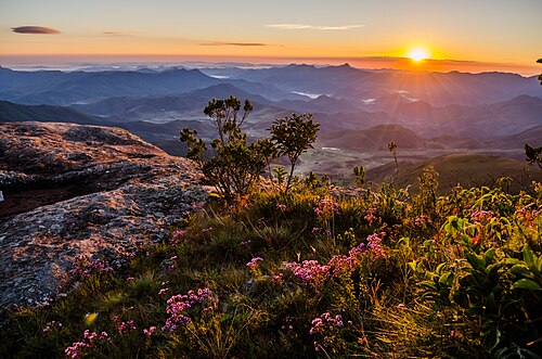
Alagoa is a small municipality in the Serra da Mantiqueira, in southern Minas Gerais. It sits more than 1,100 m above sea level, and its highest point is the Pico do Garrafão, at 2,359 m. It is known for its artisanal cheeses. Mining was the first economic activity, followed by farming and ranching.
Alagoa at a glance
- Population: 2,7 thousand
- Area: 161,4 km²
- Elevation: 1.132 m
- Distance from Belo Horizonte: 420 km
- Demonym: alagoense
- Founded: 1962
- Region: Southern Minas
- Tourism region: IGR Terras Altas da Mantiqueira
- Area code: 35
- IBGE code: 3101300
Alagoa is part of the tourism region IGR Terras Altas da Mantiqueira.
History
The region was inhabited by the Cataguá Indigenous people. Its wealth in gold and precious stones attracted backcountry explorers. Around 1730, Simão da Cunha Gago and Father Joaquim Mendes de Carvalho founded a settlement and a chapel, a branch of the Matriz de Aiuruoca.
In 1752 a church was built, constructed by enslaved people. In 1758 the place became a curacy and, in 1855, a parish. The name comes from a large lake, drained to mine for gold, with a channel cut through the so-called pedra furada ("pierced rock").
Alagoa was a district of Itamonte and became a municipality under State Law No. 2,764 of December 30, 1962. It was formally established on March 1, 1963.
Timeline
- c. 1730 · The settlement and chapel are founded
- 1752 · The church is built, constructed by enslaved people
- 1758 · Raised to curacy status
- 1855 · The parish is created
- 1962 · Independence from Itamonte
- 1963 · The municipality is established
Things to do in Alagoa: attractions
Pico do Garrafão (Santo Agostinho)
Nature
The highest point in the municipality, at 2,359 m.
Alagoa cheese route
Market
Farms that produce the town's artisanal cheese.
Heritage
- Escola Márcia do Carmo Lima Pinto e Cel. Porfírio Mendes Pinto · School building listed by the municipality.
Nature
- Pico do Garrafão · The highest point in the municipality, at 2,359 m.
Rivers and waters
- River basin: Grande River (Paraná River basin)
- Rivers: Rio Aruruoca, Rio do Quilombo, Ribeirão dos Campos, Ribeirão Santo Agostinho, Córrego Condato
Climate
- Type: Central Brazil tropical, mild mesothermal, humid (3 dry months)
- Winter: Coldest month averages between 10 and 15 °C.
Typical food
- Queijo Alagoa · An artisanal cheese known throughout Brazil. It was once mentioned as a form of currency in town.
Festivals and events
- Festival do Queijo e do Azeite (Jun) · Organized by the town government, with concerts, food and a regional cheese contest with EMATER-MG.
Fun facts
- The name comes from a large lake drained by bandeirantes (colonial explorers) in search of gold.
- The municipality's anniversary is on December 28.
Getting there
- Itamonte · 38 km via LMG-881
- São Lourenço · 80 km
- Caxambu · 81 km
Notable people from Alagoa
- Simão da Cunha Gago · One of the founders of the settlement, around 1730
- Padre Joaquim Mendes de Carvalho · One of the founders of the settlement and of the chapel
- Padre Joaquim Inácio de Melo · First vicar of the parish
- Guarda-Mor Bento Chaves · Historic resident mentioned in local history
City hall
- Mayor: Sebastião Mendes Pinto Neto (PSDB), term 2025–2028
- Address: Praça Manoel Mendes de Carvalho, 164, Centro, Alagoa, MG, CEP 37458-000
- Phone: (35) 3366-1448
- Opening hours: Weekdays, 9 am to 5 pm
- Website: www.alagoa.mg.gov.br
Frequently asked questions
Where is Alagoa?
Alagoa is a municipality in the state of Minas Gerais, Brazil, in the Southern Minas region, 420 km from Belo Horizonte.
What is there to do in Alagoa?
The attractions of Alagoa include Pico do Garrafão (Santo Agostinho), Rota do queijo de Alagoa.
What is the population of Alagoa?
Alagoa has about 2,7 thousand inhabitants in an area of 161,4 km².
What is the typical food of Alagoa?
Queijo Alagoa (An artisanal cheese known throughout Brazil. It was once mentioned as a form of currency in town).
How do you get to Alagoa?
Itamonte: 38 km via LMG-881. São Lourenço: 80 km. Caxambu: 81 km.
Who was born in Alagoa?
Notable people from Alagoa include Simão da Cunha Gago, Padre Joaquim Mendes de Carvalho, Padre Joaquim Inácio de Melo, Guarda-Mor Bento Chaves.
Which tourism region is Alagoa part of?
Alagoa is part of IGR Terras Altas da Mantiqueira, one of the 47 official tourism regions of Minas Gerais, with 9 municipalities.
What are the festivals of Alagoa?
Festival do Queijo e do Azeite (Jun).
What are people from Alagoa called?
People born in Alagoa are called alagoense.
Towns near Alagoa
- Aiuruoca · 22 km in a straight line
- Bocaina de Minas · 25 km in a straight line
- Carvalhos · 26 km in a straight line
- Itamonte · 27 km in a straight line
- Seritinga · 31 km in a straight line
- Itanhandu · 33 km in a straight line
- Serranos · 34 km in a straight line
- Pouso Alto · 34 km in a straight line