Camanducaia, Minas Gerais
Gateway to Monte Verde · Serra da Mantiqueira
Camanducaia lies in southern Minas Gerais (Sul de Minas), on the border with São Paulo, within the Serra da Mantiqueira. The name comes from Tupi and is remembered as meaning fava beans or burnt beans. The municipality is home to Monte Verde, a tourist district with Alpine-style architecture and cold winters, popular all year round. Part of its territory lies within the APA Fernão Dias. The highest point is the Pedra de São Domingos, at 2,056 m.
Camanducaia at a glance
- Population: 26 thousand
- Area: 528 km²
- Elevation: 1.000 m
- Distance from Belo Horizonte: 473 km
- Demonym: camanducaiense
- Founded: 1840
- Region: Southern Minas
- Tourism region: IGR Serras Verdes do Sul de Minas
- Area code: 35
- IBGE code: 3110509
Camanducaia is part of the tourism region IGR Serras Verdes do Sul de Minas.
History
No one knows for sure how the settlement began. The most widely accepted hypothesis is that bandeirantes from São Paulo, on a route coming from Atibaia, built the first houses in the mid-18th century. The village predates 1775 and had a chapel dedicated to Nossa Senhora da Conceição, today the town's patron saint.
The district was created in 1766 and the parish in 1775. In 1840 the municipality was born under the name Jaguari, split off from Pouso Alegre, and its seat was established in 1842. In 1868 the locality was elevated to the status of city. The judicial district was created in 1891 and established in 1892.
In 1930 the municipality was renamed Camanducaia, a name of Tupi origin that the settlement had used before. Today it has two districts, the seat and São Mateus de Minas, as well as Monte Verde, which concentrates the region's tourism.
Among the founders of Monte Verde was the Latvian immigrant Verner Grinberg, whose influence shapes the identity and architecture of the place.
Timeline
- 1766 · District created
- 1775 · Elevated to parish
- 1840 · Municipality created, under the name Jaguari
- 1842 · Town seat established
- 1868 · Elevated to city
- 1892 · Judicial district established
- 1930 · Municipality renamed Camanducaia
- 1997 · APA Fernão Dias created
Things to do in Camanducaia: attractions
Monte Verde
Tourist district · District of Monte Verde
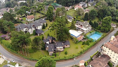
A village with Alpine-style architecture in the Mantiqueira, with restaurants, cafés, chocolate shops, and craft breweries along Avenida Monte Verde.
Pico do Selado
Viewpoint · Monte Verde
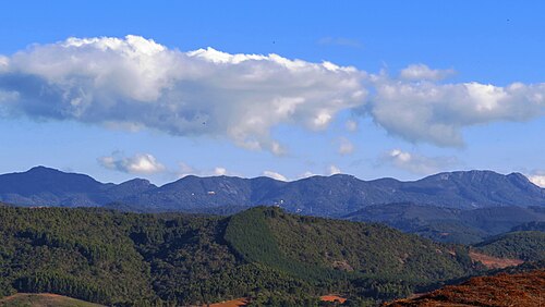
A 2,082 m peak in Monte Verde, one of the highest points in the region.
Pedra Redonda
Nature · Monte Verde
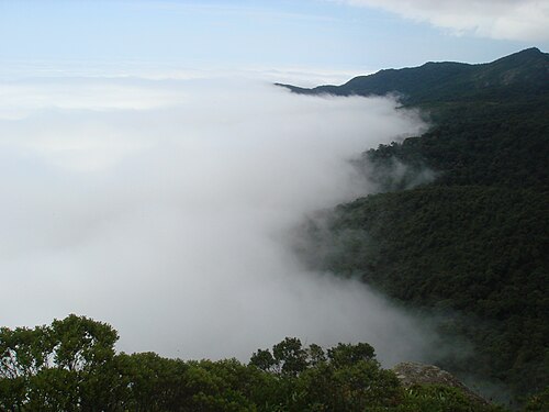
A very popular trail, with sweeping views of the Serra da Mantiqueira.
Chapéu do Bispo
Nature · Monte Verde
One of the most sought-after trails in Monte Verde, with good views.
Pinheiro Velho
Nature · Monte Verde
An easy trail near the center of Monte Verde.
Falconry school
Attraction · Monte Verde
Visitors meet birds of prey and watch demonstrations with specialists.
Igreja Matriz e Praça do Centenário
Church · Centro, Camanducaia
Part of the historic center of Camanducaia's town seat.
Grutas José Pereira
Nature
A natural attraction listed among the municipality's sights.
Cachoeira do Quinzinho
Waterfall
A waterfall with trout fishing.
Heritage
- APA Fernão Dias · Environmental protection area created in 1997, covering 180,000 hectares, partly within the municipality
- Igreja Matriz de Nossa Senhora da Conceição · Dedicated to the town's patron saint, tied to the settlement's origins
- Pedra de São Domingos · The highest point in the municipality, at 2,056 m
Nature
- APA Fernão Dias · A conservation area created in 1997 that covers part of the municipality
- Serra da Mantiqueira · Peaks above 1,800 m, with Pico do Selado at 2,082 m
Rivers and waters
- River basin: Tietê River (Paraná River basin), Piracicaba River sub-basin
- Rivers: Ribeirão Camanducaia, Rio Mandu, Rio Sapucaí-Mirim
Climate
- Type: Temperate oceanic (Cfb)
- Winter: Dry and cold, with frequent frost and rare snow in Monte Verde
- Summer: Humid
- Best time to visit: June to August for Monte Verde's cold weather. Spring and fall have more stable weather
Typical food
- Fondue · A signature dish on Monte Verde menus
- Trout · Trout, served at restaurants and fish farms in the region
- Hot chocolate · Hot chocolate, considered a symbol of the destination
- Artisanal cheeses and jams · Products from small producers, such as Edelweiss jams
Festivals and events
- Street Carnival (fev) · Revelry in the town center
- Winter in the Mountains Festival (jul) · Free concerts in Monte Verde between July and August
- Patron Saint Festival (dez) · On December 8, the day of Nossa Senhora da Conceição
- Christmas in the Mountains (dez) · Themed decorations and events in Monte Verde
Fun facts
- The name Camanducaia comes from Tupi and is translated as fava beans or burnt beans.
- Between 1840 and 1930 the municipality was called Jaguari.
- In 1833 residents proclaimed a local independence and erected the pelourinho (pillory), before the town was legally created.
- Monte Verde is called the "Switzerland of Minas" (Suíça Mineira).
Getting there
- São Paulo · About 165 km to Monte Verde, a little over 2.5 hours by car
Districts
Notable people from Camanducaia
- Baptista Caetano · The poet Macambúzio. Researcher of Indigenous languages and state representative between 1830 and 1838
- Cláudio Furquim de Almeida · Settler who established himself near the Camanducaia stream in 1757
- Verner Grinberg · Latvian immigrant credited with founding Monte Verde
People born in Camanducaia
- Caetano Furquim de Almeida · Empreendedor · 1816–1879
- Francisco de Assis Furquim de Almeida · Brazilian politician
- Francisco Escobar · Brazilian politician and intellectual · 1865–1924
- Marcelo Fernando Domingues Rezende · Futebolista brasileiro · b. 1976
- Mário Casasanta · A Brazilian educator · 1898–1963
City hall
- Mayor: Rodrigo Alves de Oliveira (Rodrigão) (MDB), term 2025–2028
- Address: Avenida Targino Vargas, 45, Recanto dos Ipês, Camanducaia, MG, CEP 37650-000
- Phone: (35) 3433-1323
- Website: www.camanducaia.mg.gov.br
Frequently asked questions
Where is Camanducaia?
Camanducaia is a municipality in the state of Minas Gerais, Brazil, in the Southern Minas region, 473 km from Belo Horizonte.
What is there to do in Camanducaia?
The attractions of Camanducaia include Monte Verde, Pico do Selado, Pedra Redonda, Chapéu do Bispo, Pinheiro Velho, Escola de Falcoaria.
What is the population of Camanducaia?
Camanducaia has about 26 thousand inhabitants in an area of 528 km².
What is the typical food of Camanducaia?
Fondue (A signature dish on Monte Verde menus); Truta (Trout, served at restaurants and fish farms in the region); Chocolate quente (Hot chocolate, considered a symbol of the destination); Queijos artesanais e geleias (Products from small producers, such as Edelweiss jams).
When is the best time to visit Camanducaia?
June to August for Monte Verde's cold weather. Spring and fall have more stable weather. The climate is temperate oceanic (cfb).
How do you get to Camanducaia?
São Paulo: About 165 km to Monte Verde, a little over 2.5 hours by car.
Who was born in Camanducaia?
Notable people from Camanducaia include Baptista Caetano, Cláudio Furquim de Almeida, Verner Grinberg, Caetano Furquim de Almeida, Francisco de Assis Furquim de Almeida (brazilian politician), Francisco Escobar (brazilian politician and intellectual), Marcelo Fernando Domingues Rezende (brazilian footballer), Mário Casasanta (a brazilian educator).
Which tourism region is Camanducaia part of?
Camanducaia is part of IGR Serras Verdes do Sul de Minas, one of the 47 official tourism regions of Minas Gerais, with 20 municipalities.
What are the festivals of Camanducaia?
Street Carnival (fev), Festival Inverno nas Montanhas (jul), Patron Saint Festival (dez), Natal nas Montanhas (dez).
What are people from Camanducaia called?
People born in Camanducaia are called camanducaiense.
Towns near Camanducaia
- Itapeva · 8 km in a straight line
- Cambuí · 18 km in a straight line
- Senador Amaral · 19 km in a straight line
- Córrego do Bom Jesus · 19 km in a straight line
- Extrema · 21 km in a straight line
- Toledo · 23 km in a straight line
- Munhoz · 27 km in a straight line
- Bom Repouso · 32 km in a straight line