Extrema, Minas Gerais
Logistics and e-commerce hub · Serra da Mantiqueira, on the border with São Paulo
Extrema lies at the far southern tip of Minas Gerais, on the border with São Paulo state, about 100 km from the city of São Paulo. The name ("extreme") comes precisely from this border position. Bathed by the Rio Jaguari, part of the Sistema Cantareira basin, the town has part of its territory in the Serra da Mantiqueira. Today it is known for its large distribution centers and e-commerce, and its population grew from 28,600 (2010) to 53,500 (2022).
Extrema at a glance
- Population: 53 thousand
- Area: 245 km²
- Elevation: 900 m
- Distance from Belo Horizonte: 492 km
- Demonym: extremense
- Founded: 1925
- Region: Southern Minas
- Tourism region: IGR Serras Verdes do Sul de Minas
- Area code: 35
- IBGE code: 3125101
Extrema is part of the tourism region IGR Serras Verdes do Sul de Minas.
History
In 1764, governor Luís Diogo Lobo da Silva set up a tax checkpoint on the banks of the Rio Jaguari, at the crossing between Minas and São Paulo. The post controlled the movement of people and goods at the border.
The first formal record of a settlement dates from December 26, 1788, a baptism at the main church of Camanducaia. In 1832, the chapel of Santa Rita de Cássia established the village.
State Law No. 893, of 1925, raised Extrema to city status. With the opening of the Rodovia Fernão Dias (BR-381), the municipality became a strategic point between Belo Horizonte and São Paulo and began attracting industries and logistics centers.
Timeline
- 1764 · Tax checkpoint set up on the banks of the Rio Jaguari
- 1788 · First formal record of a settlement, a baptism at the main church of Camanducaia
- 1832 · Chapel of Santa Rita de Cássia consolidates the village
- 1925 · State Law No. 893 raises Extrema to city status
- 2010 · Census records 28,599 inhabitants
- 2022 · Census records 53,482 inhabitants
Things to do in Extrema: attractions
Pico do Lopo
Viewpoint
A trail in the Serra da Mantiqueira with views over the Extrema region.
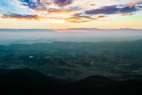
Rio Jaguari
Nature
A river that shapes the municipality's landscape and is part of the basin that feeds the Sistema Cantareira.
Serra da Mantiqueira
Nature
On the edge of the municipality, with trails, viewpoints and remnants of Atlantic Forest.
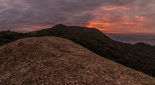
Igreja Matriz de Santa Rita de Cássia
Church
A church linked to the 1832 chapel of Santa Rita de Cássia, which gave rise to the village.
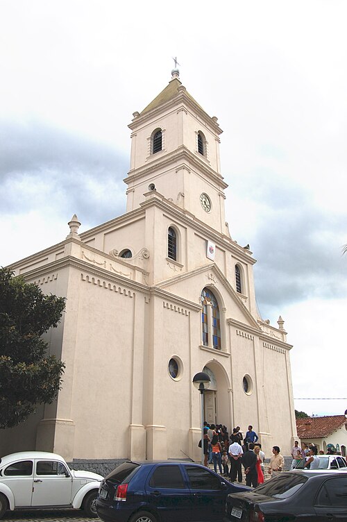
Heritage
- Igreja Matriz de Santa Rita · Sanctuary at the town's ground zero, cited by the town government as a listed property.
- Capela de Nossa Senhora da Conceição Aparecida · Chapel in the Salto do Meio neighborhood, listed by the municipality.
- Capela de Nossa Senhora da Imaculada Conceição · Chapel in the Godoi neighborhood, listed by the municipality.
Nature
- Serra da Mantiqueira · Remnants of Atlantic Forest, trails and viewpoints.
- Rio Jaguari · Part of the basin that supplies the Sistema Cantareira.
Rivers and waters
- River basin: Grande River, Piracicaba, Capivari and Jundiaí (PCJ) sub-basin via the Jaguari River
- Rivers: Rio Jaguari
Climate
- Type: Central Brazil tropical, mild mesothermal, humid (3 dry months)
- Winter: Coldest month averages between 10 and 15 °C.
Typical food
- Strawberries (morango) · The fruit has its own festival in town, with four days of free events at the Parque Municipal de Eventos.
Festivals and events
- Feast of Santa Rita (Mai) · Lasts the whole month of May, with celebrations at the Santuário de Santa Rita and concerts.
Fun facts
- The name Extrema comes from its position at the far southern tip of Minas Gerais, on the border with São Paulo.
- About 1 in every 4 products sold in Brazilian e-commerce ships from Extrema, according to a local source.
- The 2023 GDP per capita was R$ 377,800, the highest in Minas Gerais, according to the same source.
- The municipality has more than 1 million m² of logistics warehouses.
Getting there
- São Paulo · about 100 km via the Rodovia Fernão Dias (BR-381)
Districts
- Juncal
Notable people from Extrema
- José Alves · Farmer who asked, in 1832, for permission to build the chapel of Santa Rita de Cássia, the town's origin.
- Luís Diogo Lobo da Silva · Governor of the Captaincy of Minas who, in 1764, ordered a tax checkpoint set up on the banks of the Rio Jaguari.
People born in Extrema
- Claudemir Maciel da Silva · Político brasileiro · b. 1971
- Everson Zoio · Youtuber e dj brasileiro · b. 1992
City hall
- Mayor: Fabrício Sanchez Bergamin (PDT), term 2025–2028
- Address: Avenida Delegado Waldemar Gomes Pinto, 1624, Ponte Nova, Extrema, MG, CEP 37642-350
- Phone: (35) 3435-3521
- Website: extrema.mg.gov.br
Frequently asked questions
Where is Extrema?
Extrema is a municipality in the state of Minas Gerais, Brazil, in the Southern Minas region, 492 km from Belo Horizonte.
What is there to do in Extrema?
The attractions of Extrema include Pico do Lopo, Rio Jaguari, Serra da Mantiqueira, Igreja Matriz de Santa Rita de Cássia.
What is the population of Extrema?
Extrema has about 53 thousand inhabitants in an area of 245 km².
What is the typical food of Extrema?
Strawberries (morango) (The fruit has its own festival in town, with four days of free events at the Parque Municipal de Eventos).
How do you get to Extrema?
São Paulo: about 100 km via the Rodovia Fernão Dias (BR-381).
Who was born in Extrema?
Notable people from Extrema include José Alves, Luís Diogo Lobo da Silva, Claudemir Maciel da Silva (brazilian politician), Everson Zoio (brazilian youtuber and dj).
Which tourism region is Extrema part of?
Extrema is part of IGR Serras Verdes do Sul de Minas, one of the 47 official tourism regions of Minas Gerais, with 20 municipalities.
What are the festivals of Extrema?
Feast of Santa Rita (Mai).
What are people from Extrema called?
People born in Extrema are called extremense.
Towns near Extrema
- Toledo · 14 km in a straight line
- Itapeva · 14 km in a straight line
- Camanducaia · 21 km in a straight line
- Munhoz · 28 km in a straight line
- Senador Amaral · 33 km in a straight line
- Cambuí · 38 km in a straight line
- Córrego do Bom Jesus · 39 km in a straight line
- Bueno Brandão · 46 km in a straight line