Cambuquira, Minas Gerais
Planned town of mineral waters · Circuito das Águas
Cambuquira is a mineral spring spa town in southern Minas, on the Circuito das Águas (Water Circuit). It was one of the first planned towns in the state, with wide streets and many magnolias that bloom in spring. The Parque das Águas brings together mineral springs, and the Pico do Piripau hosts paragliding and hang-gliding flights. The town also has an astronomical observatory open to visitors.
Cambuquira at a glance
- Population: 12,3 thousand
- Area: 246 km²
- Elevation: 950 m
- Distance from Belo Horizonte: 258 km in a straight line
- Demonym: cambuquirense
- Founded: 1909
- Region: Southern Minas
- Tourism region: IGR Águas
- Area code: 35
- IBGE code: 3110707
Cambuquira is part of the tourism region IGR Águas.
History
The region was inhabited by the Puri people. The town was born on the old Fazenda Boa Vista, part of which three sisters of the Silva Gularte family left to formerly enslaved people. Drawn by the mineral waters, outsiders began to frequent the place, and the Câmara de Campanha (Campanha town council) expropriated the land with the springs in 1861.
In 1872 the settlement of Cambuquira was founded, as a district of Campanha. The name may come from an ensign nicknamed Cambuquira, who sold squash shoots, or from the large production of these shoots, the hypothesis considered more likely. The railway station opened in 1894 and the hydrotherapy establishment of the Parque das Águas in 1899.
The municipality was created in 1909 and formally established in 1912. In 1970 the town received the title of mineral spring spa town.
Timeline
- 1861 · The Câmara de Campanha expropriates the land with the springs
- 1872 · Founding of the settlement of Cambuquira
- 1894 · Opening of the railway station
- 1899 · Opening of the hydrotherapy establishment of the Parque das Águas
- 1909 · Creation of the municipality
- 1912 · Formal establishment of the municipality
- 1970 · Title of mineral spring spa town
Things to do in Cambuquira: attractions
Parque das Águas
Nature · Town center
Park with six mineral water springs.
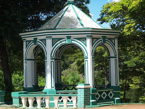
Fonte do Marimbeiro
Spring
One of the town's historic springs.
Fonte do Laranjal
Spring
Mineral water spring on the circuit.
Pico do Piripau
Viewpoint
About 1,300 m in altitude, used for paragliding and hang-gliding flights.
Observatório Centauro (Centro de Estudos de Astronomia)
Museum
Observatory open to visitors.
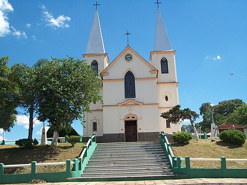
Igreja Matriz de São Sebastião
Church · Town center
Mother church built around 1920 and inaugurated in 1925, according to Wikipedia.
Cachoeira do Congonhal
Waterfall · Congonhal
Waterfall in the countryside.
Heritage
- Parque das Águas · Set of springs and hydrotherapy establishment from 1899
- Igreja Matriz de São Sebastião · Mother church inaugurated in 1925
Nature
- Pico do Piripau · About 1,300 m, free-flight launch ramp
- Parque das Águas · Six mineral springs
Rivers and waters
- River basin: Grande River (Paraná River basin), Sapucaí River sub-basin 2
- Rivers: Rio Lambari, Rio São Bento, Ribeirão Barreiro, Ribeirão Lambarizinho, Córrego São Domingos
Climate
- Type: Central Brazil tropical, subwarm, humid (3 dry months)
- Winter: At least one month averages between 15 and 18 °C.
- Best time to visit: Spring, when the magnolias bloom
Festivals and events
- Dia de São Sebastião (January 20) (Jan) · Feast day of the town's patron saint, according to Wikipedia
Fun facts
- It is one of the first planned towns in Minas.
- The name comes from Tupi, and the town was once called São Sebastião de Cambuquira and Águas Virtuosas de Cambuquira.
- The Centro de Estudos de Astronomia was founded in 1961, according to Wikipedia.
- It is part of the Circuito das Águas of Minas Gerais.
Getting there
- Belo Horizonte · 258 km in a straight line; road distance not confirmed
Notable people from Cambuquira
- Raul de Noronha Sá · First mayor of the municipality, in 1909
- Irmãs Silva Gularte · Owners of Fazenda Boa Vista, the origin of the town
People born in Cambuquira
- Christina Lemos · Brazilian journalist
- Hilton Ribeiro da Rocha · Physician · 1911–1993
- Joselita Alvarenga · Brazilian actress · 1934–2020
- José Vieira Brandão · Brazilian pianist · 1911–2002
- João Signorelli · Brazilian actor · 1956–2026
City hall
- Mayor: Cimara Beatriz Arci Salgado Machado (Cimara da Saúde) (Republicanos), term 2025–2028
- Address: Avenida Virgílio de Melo Franco, 555, Centro, Cambuquira, MG, CEP 37420-000
- Phone: (35) 3251-2000
- Website: www.cambuquira.mg.gov.br
Frequently asked questions
Where is Cambuquira?
Cambuquira is a municipality in the state of Minas Gerais, Brazil, in the Southern Minas region, 258 km em linha reta from Belo Horizonte.
What is there to do in Cambuquira?
The attractions of Cambuquira include Parque das Águas, Fonte do Marimbeiro, Fonte do Laranjal, Pico do Piripau, Observatório Centauro (Centro de Estudos de Astronomia), Igreja Matriz de São Sebastião.
What is the population of Cambuquira?
Cambuquira has about 12,3 thousand inhabitants in an area of 246 km².
When is the best time to visit Cambuquira?
Spring, when the magnolias bloom. The climate is central brazil tropical, subwarm, humid (3 dry months).
How do you get to Cambuquira?
Belo Horizonte: 258 km in a straight line; road distance not confirmed.
Who was born in Cambuquira?
Notable people from Cambuquira include Raul de Noronha Sá, Irmãs Silva Gularte, Christina Lemos (brazilian journalist), Hilton Ribeiro da Rocha (physician), Joselita Alvarenga (brazilian actress), José Vieira Brandão (brazilian pianist), João Signorelli (brazilian actor).
Which tourism region is Cambuquira part of?
Cambuquira is part of IGR Águas, one of the 47 official tourism regions of Minas Gerais, with 15 municipalities.
What are the festivals of Cambuquira?
Dia de São Sebastião (January 20) (Jan).
What are people from Cambuquira called?
People born in Cambuquira are called cambuquirense.
Towns near Cambuquira
- Campanha · 12 km in a straight line
- Lambari · 14 km in a straight line
- Jesuânia · 15 km in a straight line
- Três Corações · 18 km in a straight line
- Conceição do Rio Verde · 21 km in a straight line
- Olímpio Noronha · 24 km in a straight line
- Monsenhor Paulo · 28 km in a straight line
- São Gonçalo do Sapucaí · 31 km in a straight line