Coronel Xavier Chaves, Minas Gerais
Land of the Capela do Rosário · Campo das Vertentes
Coronel Xavier Chaves is a small municipality in the Campo das Vertentes, in the Immediate Geographic Region of São João del-Rei. It grew out of the division of the Fazenda do Mosquito, inherited by the colonel the town is named after. The little stone church of Nossa Senhora do Rosário is the oldest building of the former farm. The town has a strong musical tradition and draws visitors with rural tourism, cheese and cachaça.
Coronel Xavier Chaves at a glance
- Population: 3,5 thousand
- Area: 141 km²
- Elevation: 906 m
- Distance from Belo Horizonte: 174 km
- Demonym: xavierense
- Founded: 1962
- Region: Zona da Mata and Vertentes
- Tourism region: IGR Trilha dos Inconfidentes
- Area code: 32
- IBGE code: 3119708
Coronel Xavier Chaves is part of the tourism region IGR Trilha dos Inconfidentes.
History
There are accounts of residents in the region around 1700, from the family of João Gonçalves de Faria Góes e Lara. The chapel of Nossa Senhora da Conceição do Mosquito appears in 18th-century records, and a sesmaria (land grant) from 1718 is the oldest document found.
The Fazenda do Mosquito was inherited by Colonel Francisco Rodrigues Xavier Chaves and divided among his children. That division gave rise to the urban core, which the city government describes as a planned town.
The settlement became a district in 1911, under the name São Francisco Xavier, belonging to Prados. In 1943 it was renamed Coroas. Emancipation came with Law 2,764 of 1962, under the current name. The town's anniversary is celebrated on March 1.
Timeline
- c. 1700 · First residents in the region, from the family of João Gonçalves de Faria Góes e Lara
- 1718 · Oldest sesmaria found in the Mosquito area
- c. 1717 · Date attributed to the Capela de Nossa Senhora do Rosário
- 1911 · Becomes a district of Prados, as São Francisco Xavier
- 1943 · District renamed Coroas
- 1962 · Emancipation by Law 2,764, under the name Coronel Xavier Chaves
Things to do in Coronel Xavier Chaves: attractions
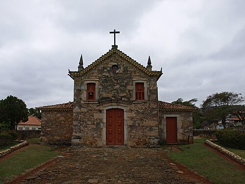
Capela de Nossa Senhora do Rosário
Church
A little stone church, the oldest surviving building of the former farm. It dates from around 1717.
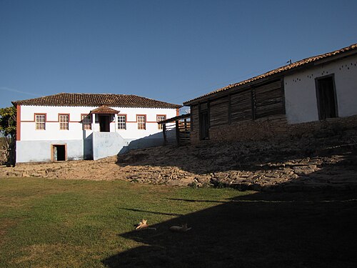
Fazenda Cachoeira
Historic farm
A farm cited as a property of historic interest in the municipality.
Espaço Municipal de Lazer e Convivência
Square · Bairro Vila Fátima
A recreation area in the Vila Fátima neighborhood.
Estrada Real, Trilha dos Inconfidentes
Nature
The town is part of routes on the Estrada Real and the newly created Trilha de São Tiago.
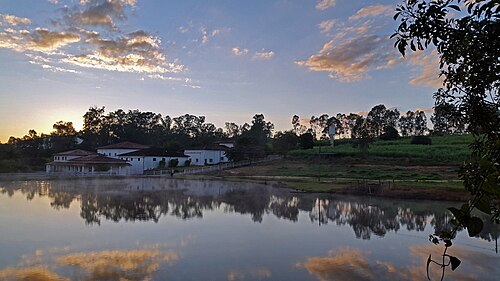
Hotel Fazenda Bela Vista
Rural tourism
A farm hotel with a cachaça still, cited on Wikipedia.
Heritage
- Capela de Nossa Senhora do Rosário · A stone building from around 1717
- Fazenda Cachoeira · A property of historic interest
Nature
- Serra de São José · A quartzite massif stretching across Coronel Xavier Chaves and neighboring towns, with rocky grasslands, springs and waterfalls.
- APA São José · Environmental protection area of the Serra de São José, with Atlantic Forest and Cerrado.
Rivers and waters
- River basin: Grande River (Paraná River basin)
- Rivers: Ribeirão do Mosquito
Climate
- Type: Central Brazil tropical, subwarm, semi-humid (4 to 5 dry months)
- Winter: At least one month averages between 15 and 18 °C.
Typical food
- Artisanal cheese · A featured product at the regional festival
- Cachaça · Produced in the region's stills
Festivals and events
- Moscoxaves · A town event, with editions from 2022 to 2025 announced by the city government
- Festival do Queijo e da Cachaça das Vertentes · A regional festival, with the 3rd edition announced by the city government
Fun facts
- The town was born planned, from the division of the Fazenda do Mosquito.
- It has been called São Francisco Xavier and Coroas.
- It has a strong musical tradition, with a brass band, artisans and painters.
- The Fazenda do Pombal, where Tiradentes was born, is about 8 km from the town center, in Ritápolis.
Getting there
- Ritápolis · The Fazenda do Pombal, where Tiradentes was born, is about 8 km from the town center
Notable people from Coronel Xavier Chaves
- Coronel Francisco Rodrigues Xavier Chaves · Heir to the Fazenda do Mosquito, honored in the town's name
- João Gonçalves de Faria Góes e Lara · Patriarch of the family linked to the region's first residents
City hall
- Mayor: Sidinei Resende Paiva (REDE), term 2025–2028
- Address: Rua Padre Reis, 84, Centro, Coronel Xavier Chaves, MG, CEP 36330-000
- Phone: (32) 3216-1053
- Opening hours: 8h às 16h
- Website: coronelxavierchaves.mg.gov.br/prefeitura
Frequently asked questions
Where is Coronel Xavier Chaves?
Coronel Xavier Chaves is a municipality in the state of Minas Gerais, Brazil, in the Zona da Mata and Vertentes region, 174 km from Belo Horizonte.
What is there to do in Coronel Xavier Chaves?
The attractions of Coronel Xavier Chaves include Capela de Nossa Senhora do Rosário, Fazenda Cachoeira, Espaço Municipal de Lazer e Convivência, Estrada Real, Trilha dos Inconfidentes, Hotel Fazenda Bela Vista.
What is the population of Coronel Xavier Chaves?
Coronel Xavier Chaves has about 3,5 thousand inhabitants in an area of 141 km².
What is the typical food of Coronel Xavier Chaves?
Artisanal cheese (A featured product at the regional festival); Cachaça (Produced in the region's stills).
How do you get to Coronel Xavier Chaves?
Ritápolis: The Fazenda do Pombal, where Tiradentes was born, is about 8 km from the town center.
Who was born in Coronel Xavier Chaves?
Notable people from Coronel Xavier Chaves include Coronel Francisco Rodrigues Xavier Chaves, João Gonçalves de Faria Góes e Lara.
Which tourism region is Coronel Xavier Chaves part of?
Coronel Xavier Chaves is part of IGR Trilha dos Inconfidentes, one of the 47 official tourism regions of Minas Gerais, with 25 municipalities.
What are the festivals of Coronel Xavier Chaves?
Moscoxaves, Festival do Queijo e da Cachaça das Vertentes.
What are people from Coronel Xavier Chaves called?
People born in Coronel Xavier Chaves are called xavierense.
Towns near Coronel Xavier Chaves
- Tiradentes · 10 km in a straight line
- Ritápolis · 10 km in a straight line
- Santa Cruz de Minas · 11 km in a straight line
- São João del Rei · 12 km in a straight line
- Resende Costa · 12 km in a straight line
- Prados · 15 km in a straight line
- Lagoa Dourada · 19 km in a straight line
- Dores de Campos · 23 km in a straight line