Ritápolis, Minas Gerais
Birthplace of Tiradentes · Campo das Vertentes
Ritápolis is 14 km from São João del-Rei and is the birthplace of Tiradentes. The Fazenda do Pombal, where he was born, lies within the municipality. The village was founded by tropeiros (mule drivers) in the 18th century and has the Santuário de Santa Rita de Cássia, which draws pilgrimages in May. The landscape mixes Atlantic Forest and cerrado.
Ritápolis at a glance
- Population: 5 thousand
- Area: 405 km²
- Elevation: 1,000 to 1,100 m (main square)
- Distance from Belo Horizonte: 200 km
- Demonym: ritapolitano
- Founded: 1962
- Region: Zona da Mata and Vertentes
- Tourism region: IGR Trilha dos Inconfidentes
- Area code: 32
- IBGE code: 3156106
Ritápolis is part of the tourism region IGR Trilha dos Inconfidentes.
History
The village arose with the tropeiros, under the name Santa Rita do Rio Abaixo. Construction of the chapel began around 1713. The first documented reference is the baptism certificate of Domingos da Silva Xavier, Tiradentes' older brother, dated June 25, 1738. The place was once called Ibitutinga.
The main square, now Praça Tiradentes, was once called Largo and Arraial. The municipality was separated from São João del-Rei on December 30, 1962. The city preserves examples of architecture in stone, wattle and daub, adobe and brick.
Timeline
- 1713 · Construction of the chapel begins, around this year
- 1738 · Baptism of Domingos da Silva Xavier, the village's first record
- 1918 · Front addition to the church
- 1962 · Separation from São João del-Rei, on December 30
Things to do in Ritápolis: attractions
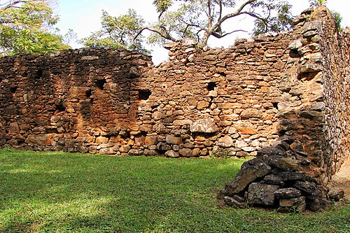
Fazenda do Pombal
Museum
Birthplace of Tiradentes, with ruins of the sugar mill.
Santuário Diocesano de Santa Rita de Cássia
Church
Draws large pilgrimages, especially in May.
Praça Tiradentes
Square
The village's main square, connected to Rua Santa Rita and the largo do Rosário.
Igreja Nossa Senhora do Rosário
Church
Church on the largo do Rosário.
Village viewpoint
Lookout
Views of the Serra de São José, the Serra do Lenheiro and the mountains of Resende Costa.
Cachoeira Jabuiú
Waterfall
Listed among the municipality's natural attractions.
Floresta Nacional de Ritápolis
Nature
Conservation unit with trails through Atlantic Forest and cerrado.
Heritage
- Fazenda do Pombal · Birthplace of Tiradentes, cited as national historic heritage.
- Capela de Santa Rita · Origin of the village, preserved despite the 1918 front addition.
- Praça Tiradentes · Historic center with houses in stone, wattle and daub, and adobe.
Nature
- Serra do Valentim · The highest point in the municipality, at 1,296 m.
- Morro Grande, Serra da Carioca e Serra dos Quatro Vinténs · Hills and ridges near the village.
Rivers and waters
- River basin: Grande River (Paraná River basin)
- Rivers: Ribeirão dos Pilões
Climate
- Type: Central Brazil tropical, subwarm, semi-humid (4 to 5 dry months)
- Winter: At least one month averages between 15 and 18 °C.
- Best time to visit: Average annual temperature of about 20 °C
Typical food
- Quitandas and sweets (doces) · Traditional Minas cooking, according to travel guides.
- Artisanal Minas Cheese (Campo das Vertentes region) · Ritápolis is part of the Campo das Vertentes region, recognized by IMA as a producer of this cheese (Portaria IMA nº 1022).
Festivals and events
- Bloco do Terror e Enterro do Zé Pereira (Feb) · Street Carnaval, on the Monday and Tuesday of Carnaval.
- Feast of Santa Rita de Cássia (May) · The city's patron saint, celebrated on May 22.
- Agricultural Fair · Agricultural and livestock fair.
- Arraial dos Gabirobas · Local popular festival.
Fun facts
- The village was once called Ibitutinga and Santa Rita do Rio Abaixo.
- Praça Tiradentes honors the city's most illustrious son.
- The Ferrovia do Aço railroad crosses part of the territory.
- The vegetation is a transition between Atlantic Forest and Cerrado.
Getting there
- São João del-Rei · 14 km
- Belo Horizonte · about 200 km
Notable people from Ritápolis
- Tiradentes · Joaquim José da Silva Xavier, born at the Fazenda do Pombal, in the municipality
- Domingos da Silva Xavier · Tiradentes' older brother, mentioned in the 1738 baptism certificate
- Luiz Carlos, José Márcio e Rejane Oliveira · Creators of the Bloco do Terror, a local Carnival street group
City hall
- Mayor: Antônio Ronato de Melo (Ronato) (PRD), term 2025–2028
- Address: Center, no. 340, Ritápolis, MG, CEP 36335-000 (street not confirmed)
- Website: ritapolis.mg.gov.br
Frequently asked questions
Where is Ritápolis?
Ritápolis is a municipality in the state of Minas Gerais, Brazil, in the Zona da Mata and Vertentes region, 200 km from Belo Horizonte.
What is there to do in Ritápolis?
The attractions of Ritápolis include Fazenda do Pombal, Santuário Diocesano de Santa Rita de Cássia, Praça Tiradentes, Igreja Nossa Senhora do Rosário, Mirante da vila, Cachoeira Jabuiú.
What is the population of Ritápolis?
Ritápolis has about 5 thousand inhabitants in an area of 405 km².
What is the typical food of Ritápolis?
Quitandas and sweets (doces) (Traditional Minas cooking, according to travel guides); Queijo Minas Artesanal (Região do Campo das Vertentes) (Ritápolis is part of the Campo das Vertentes region, recognized by IMA as a producer of this cheese (Portaria IMA nº 1022)).
When is the best time to visit Ritápolis?
Average annual temperature of about 20 °C. The climate is central brazil tropical, subwarm, semi-humid (4 to 5 dry months).
How do you get to Ritápolis?
São João del-Rei: 14 km. Belo Horizonte: about 200 km.
Who was born in Ritápolis?
Notable people from Ritápolis include Tiradentes, Domingos da Silva Xavier, Luiz Carlos, José Márcio e Rejane Oliveira.
Which tourism region is Ritápolis part of?
Ritápolis is part of IGR Trilha dos Inconfidentes, one of the 47 official tourism regions of Minas Gerais, with 25 municipalities.
What are the festivals of Ritápolis?
Bloco do Terror e Enterro do Zé Pereira (Feb), Festa de Santa Rita de Cássia (May), Exposição Agropecuária, Arraial dos Gabirobas.
What are people from Ritápolis called?
People born in Ritápolis are called ritapolitano.
Towns near Ritápolis
- Coronel Xavier Chaves · 10 km in a straight line
- São João del Rei · 13 km in a straight line
- Resende Costa · 15 km in a straight line
- Santa Cruz de Minas · 15 km in a straight line
- Tiradentes · 18 km in a straight line
- Conceição da Barra de Minas · 20 km in a straight line
- São Tiago · 24 km in a straight line
- Prados · 25 km in a straight line