Guapé, Minas Gerais
Lago de Furnas town · Southern Minas
Guapé sits on the shores of Lago de Furnas, in Southern Minas. When the reservoir was formed, starting in 1963, the old town was flooded and the new town was built on a peninsula. The statue of São Francisco de Assis in the lake marks the spot of the old church tower. The municipality has waterfalls, water sports, fishing, and coffee and cachaça production.
Guapé at a glance
- Population: 13,8 thousand
- Area: 934 km²
- Elevation: 771 m
- Distance from Belo Horizonte: 293 km
- Demonym: guapeense
- Founded: 1923
- Region: Southern Minas
- Tourism region: IGR Nascentes das Gerais e Canastra
- Area code: 35
- IBGE code: 3128105
Guapé is part of the tourism region IGR Nascentes das Gerais e Canastra.
History
The first records of the village date from 1759. In 1825 the chapel of São Francisco de Assis was built, and in 1856 the parish and the district of São Francisco de Aguapé were created.
Law No. 843 of September 7, 1923 created the municipality, which was established on February 3, 1924.
Construction of the Furnas dam began in 1957. On January 9, 1963 the floodgates were closed, and ten days later the water reached the low-lying parts of town. The lake was full by March 1965. The new town was built on higher ground.
Guapé had 206 km² of its territory flooded. José Franco's report on the relocation, in O Cruzeiro magazine, won the Esso Award in 1963.
Timeline
- 1759 · First records of the village
- 1825 · Construction of the chapel of São Francisco de Assis
- 1856 · Creation of the parish and the district
- 1923 · Creation of the municipality
- 1924 · Establishment of the municipality
- 1963 · Furnas floodgates closed and the old town flooded
- 1965 · Lago de Furnas reaches full level
- 2007 · First Brasilacro de Parapente
- 2025 · Special mayoral election
Things to do in Guapé: attractions
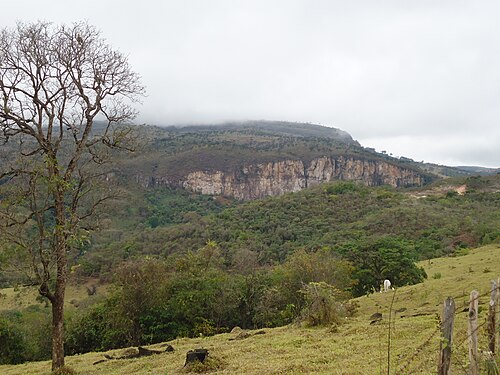
Parque Ecológico do Paredão
Nature · Rural area
Three waterfalls, trails, rappelling and rock climbing.
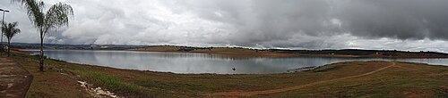
Lago de Furnas
Nature · Orla
Water sports, boat trips and fishing. The town has about 220 km of shoreline.
Estátua de São Francisco de Assis
Monument · Lago de Furnas
It stands in the lake, where the old church tower was; the tower reappears during droughts.
Cachoeiras do Macuco, do Garimpo e do Inferno
Waterfall · Rural area
The municipality's waterfalls also include Capão Quente, Água Limpa, Moinho, Lobo and Volta Grande.
Lakeside club
Club · Orla
Created by the residents themselves, it hosts traditional dances.
Bangalô
Landmark · Lago de Furnas
It still marks the lake's water level.
Heritage
- Estátua de São Francisco de Assis · Marks in the lake the spot of the old church tower
Nature
- Lago de Furnas · Covers 1,440 km² and flooded 206 km² of Guapé
- Parque Ecológico do Paredão · Three waterfalls and trails
Rivers and waters
- River basin: Grande River (Paraná River basin)
- Rivers: Rio Grande, Rio Sapucaí
Climate
- Type: Highland tropical (Cwa)
Typical food
- Coffee · Coffee grown in the municipality
- Artisanal cachaça · Craft cachaça (sugarcane spirit) made in the region
Festivals and events
- Carnival (fev) · One of the liveliest in the region
- Festa da Jacutinga (ago) · On the 15th, with a walk of about 21 km to Aparecida do Sul
- Feast of São Francisco de Assis (out) · Celebrated on October 4
Fun facts
- The name comes from an aquatic plant, the aguapé (water hyacinth).
- The motto on the flag, in Latin, means 'you will float, you will not sink'.
- During the move, the image of São Francisco was carried backward, with its face turned toward the submerged town.
- The new town was built on a peninsula.
Getting there
- Belo Horizonte · About 293 km
- Carmo do Rio Claro · Via the paved BR-265
- Boa Esperança · Via the paved MG-170
Districts
- Araúna
Notable people from Guapé
- Juscelino Kubitschek · Mastermind of the Furnas dam
- Raul Soares de Moura · Governor who signed the law creating the municipality
- José Franco · Journalist for O Cruzeiro, winner of the Esso Award for a report on the town
- Dona Esméria Angélica da Pureza · Linked to the construction of the São Francisco chapel
People born in Guapé
- Valderico Reis · Político brasileiro · b. 1944
- Welington de Melo · Brazilian mathematician · 1946–2016
City hall
- Mayor: Pedro Simões (Dr. Pedro) (PL), term 2025–2028
- Address: Praça Dr. Passos Maia, 260, Centro, Guapé, MG, CEP 37177-000
- Phone: (35) 3856-1250
- Website: www.guape.mg.gov.br
Frequently asked questions
Where is Guapé?
Guapé is a municipality in the state of Minas Gerais, Brazil, in the Southern Minas region, 293 km from Belo Horizonte.
What is there to do in Guapé?
The attractions of Guapé include Parque Ecológico do Paredão, Lago de Furnas, Estátua de São Francisco de Assis, Cachoeiras do Macuco, do Garimpo e do Inferno, Clube à beira do lago, Bangalô.
What is the population of Guapé?
Guapé has about 13,8 thousand inhabitants in an area of 934 km².
What is the typical food of Guapé?
Café (Coffee grown in the municipality); Cachaça artesanal (Craft cachaça (sugarcane spirit) made in the region).
How do you get to Guapé?
Belo Horizonte: About 293 km. Carmo do Rio Claro: Via the paved BR-265. Boa Esperança: Via the paved MG-170.
Who was born in Guapé?
Notable people from Guapé include Juscelino Kubitschek, Raul Soares de Moura, José Franco, Dona Esméria Angélica da Pureza, Valderico Reis (brazilian politician), Welington de Melo (brazilian mathematician).
Which tourism region is Guapé part of?
Guapé is part of IGR Nascentes das Gerais e Canastra, one of the 47 official tourism regions of Minas Gerais, with 20 municipalities.
What are the festivals of Guapé?
Carnival (fev), Festa da Jacutinga (ago), Feast of São Francisco de Assis (out).
What are people from Guapé called?
People born in Guapé are called guapeense.
Towns near Guapé
- Capitólio · 21 km in a straight line
- Ilicínea · 22 km in a straight line
- Carmo do Rio Claro · 31 km in a straight line
- Piumhi · 32 km in a straight line
- Pimenta · 33 km in a straight line
- Campo do Meio · 40 km in a straight line
- São José da Barra · 42 km in a straight line
- Cristais · 43 km in a straight line