Piranguinho, Minas Gerais
National capital of pé de moleque · Southern Minas
Piranguinho is a municipality in the Sul de Minas region, next to Itajubá, in the Rio Grande basin. It became known as the national capital of pé de moleque (a peanut and brown-sugar candy) and hosts the Festa do Maior Pé de Moleque do Mundo (World's Largest Pé de Moleque Festival). The economy combines agriculture and livestock, commerce and services. The railroad station was renovated and became a space for culture, tourism and leisure in 2023.
Piranguinho at a glance
- Population: 9,1 thousand
- Area: 124,8 km²
- Elevation: 840 m
- Distance from Belo Horizonte: 436 km
- Demonym: piranguinhense
- Founded: 1962
- Region: Southern Minas
- Tourism region: IGR Caminhos da Mantiqueira
- Area code: 35
- IBGE code: 3151008
Piranguinho is part of the tourism region IGR Caminhos da Mantiqueira.
History
Before the arrival of Europeans, the region was inhabited by the Puri people. The name comes from Old Tupi and may refer to the Piranguinho stream or to a red stone.
Settlement of European origin began in the late 19th century, with the construction of the Estrada de Ferro Sapucaí railroad. In 1913 the first school and the water and power infrastructure were created.
State Law No. 2.764, of December 30, 1962, made the municipality independent, and it was installed on March 1, 1963. Since the 1990s, commerce and tourism have gained weight alongside agriculture and livestock.
Timeline
- Late 19th c. · European settlement with the Estrada de Ferro Sapucaí
- 1875 · Construction date of the Igreja de Nossa Senhora do Carmo
- 1913 · Creation of the first school and the water and power infrastructure
- 1962 · Law No. 2.764 makes the municipality independent
- 1963 · Installation of the municipality, on March 1
- 2023 · 28-m record at the 16th Festa do Maior Pé de Moleque do Mundo
- 2023 · Renovated station becomes the Espaço de Cultura, Turismo e Lazer
Things to do in Piranguinho: attractions
Praça Coronel Bráz
Square · Town center
The town's central square.
Igreja Matriz de Santa Isabel
Church
Church of the patron saint, whose feast is on July 4.
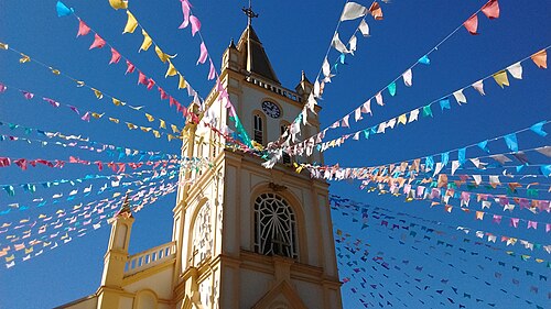
Igreja de Nossa Senhora do Carmo
Church
Church from 1875.
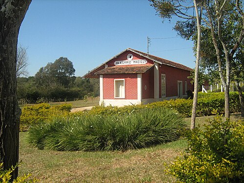
Olegário Maciel railway station
Museum · Olegário Maciel
Station in the district of Olegário Maciel, tied to the history of the railroad.
Culture, Tourism and Leisure Space (former Station)
Culture
Station renovated and reopened in September 2023.
Bridge to Itajubá
Landmark
Bridge built in the late 19th century over the Sapucaí River, linking the two towns.
Monumento Abraço
Monument
A monument of the town.
Pico da Boa Vista
Nature
Highest point in the municipality, at 1,399 m.
Heritage
- Igreja de Nossa Senhora do Carmo · Church from 1875.
- Railway station · Renovated and reopened as a cultural space in 2023.
- Bridge to Itajubá · Built in the late 19th century.
Nature
- Pico da Boa Vista · Highest point, at 1,399 m above sea level.
- Rio Sapucaí · Main watercourse in the municipality.
Rivers and waters
- River basin: Grande River Basin
- Rivers: Rio Sapucaí, Ribeirão dos Porcos, Ribeirão Piranguinho, Ribeirão Vargem Grande
Climate
- Type: Humid mesothermal tropical (Cwa)
- Winter: Dry and cold
- Summer: Rainy
- Best time to visit: From April to September, for dry weather
Typical food
- Pé de moleque (peanut brittle) · The town's signature candy; it calls itself the national capital of pé de moleque.
- Banana, coffee and orange · Bananas, coffee and oranges are among the municipality's permanent crops.
Festivals and events
- Carnival (Feb) · Traditional festival in town.
- June festivals (Jun) · June festivals, held in June or July.
- Feast of Santa Isabel (Jul) · Patron saint, celebrated on July 4.
- Feast of Santa Ifigênia (Sep) · Religious celebration in September.
- Christmas (Dec) · Christmas program.
- Festa do Maior Pé de Moleque do Mundo · In 2023, at the 16th edition, the candy reached 28 meters.
Fun facts
- The town is called the national capital of pé de moleque.
- The giant candy at the 2023 festival set the record of 28 meters.
- The town center sits at 840 m, and the Pico da Boa Vista reaches 1,399 m.
- The railroad station became a cultural space in 2023.
Getting there
- Belo Horizonte · About 436 km by road
- Itajubá · Neighboring town, linked by a bridge over the Sapucaí
Districts
Notable people from Piranguinho
- Leocádia de Lourenço · Baroness who owned the region's land until the mid-19th century. She supplied timber and built the sawmill for the railroad ties, the origin of the settlement.
- Gregório Pereira Mota · Owner of Fazenda do Capote, he built the Capela de Nossa Senhora do Carmo, the Capela do Capote, in 1875.
City hall
- Mayor: Paulo Renato Germiniani Ribeiro (União Brasil), term 2025–2028
- Address: Avenida Alferes Reno, 200, Centro, Piranguinho, MG, CEP 37508-000
- Website: www.piranguinho.mg.gov.br
Frequently asked questions
Where is Piranguinho?
Piranguinho is a municipality in the state of Minas Gerais, Brazil, in the Southern Minas region, 436 km from Belo Horizonte.
What is there to do in Piranguinho?
The attractions of Piranguinho include Praça Coronel Bráz, Igreja Matriz de Santa Isabel, Igreja de Nossa Senhora do Carmo, Estação ferroviária de Olegário Maciel, Espaço de Cultura, Turismo e Lazer (antiga Estação), Ponte com Itajubá.
What is the population of Piranguinho?
Piranguinho has about 9,1 thousand inhabitants in an area of 124,8 km².
What is the typical food of Piranguinho?
Pé de moleque (The town's signature candy; it calls itself the national capital of pé de moleque); Banana, café e laranja (Bananas, coffee and oranges are among the municipality's permanent crops).
When is the best time to visit Piranguinho?
From April to September, for dry weather. The climate is humid mesothermal tropical (cwa).
How do you get to Piranguinho?
Belo Horizonte: About 436 km by road. Itajubá: Neighboring town, linked by a bridge over the Sapucaí.
Who was born in Piranguinho?
Notable people from Piranguinho include Leocádia de Lourenço, Gregório Pereira Mota.
Which tourism region is Piranguinho part of?
Piranguinho is part of IGR Caminhos da Mantiqueira, one of the 47 official tourism regions of Minas Gerais, with 18 municipalities.
What are the festivals of Piranguinho?
Carnaval (Feb), Festas juninas (Jun), Festa de Santa Isabel (Jul), Festa de Santa Ifigênia (Sep), Natal (Dec), Festa do Maior Pé de Moleque do Mundo.
What are people from Piranguinho called?
People born in Piranguinho are called piranguinhense.
Towns near Piranguinho
- São José do Alegre · 8 km in a straight line
- Itajubá · 8 km in a straight line
- Brazópolis · 12 km in a straight line
- Piranguçu · 15 km in a straight line
- Pedralva · 19 km in a straight line
- Maria da Fé · 19 km in a straight line
- Wenceslau Braz · 24 km in a straight line
- Santa Rita do Sapucaí · 24 km in a straight line