Rio Acima, Minas Gerais
City of waterfalls · Gateway to the Serra do Gandarela
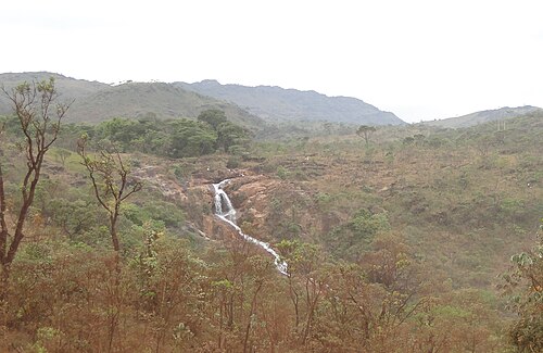
Rio Acima sits on the banks of the Rio das Velhas, in Greater BH, along a stretch of the Estrada Real. It began around 1736 as the settlement of Santo Antônio de Rio Acima, built around a chapel. It is known as the city of waters, with dozens of waterfalls, such as Cachoeira do Viana and Cachoeira do Índio. Its entire territory lies within the APA Sul, and the city is a gateway to the Parque Nacional da Serra do Gandarela. The Festa de Santo Antônio, in June, and the Festival da Goiaba (guava festival), in April, are the big events of the year.
Rio Acima at a glance
- Population: 10 thousand
- Area: 229 km²
- Elevation: 743 m
- Distance from Belo Horizonte: 34 km
- Demonym: rio-acimense
- Founded: 1948
- Region: Greater BH and Central
- Tourism region: IGR Ouro
- Area code: 31
- IBGE code: 3154804
Rio Acima is part of the tourism region IGR Ouro.
History
The settlement of Santo Antônio de Rio Acima arose around 1736 on the banks of the Rio das Velhas, at a crossing point on the Estrada Real. Bandeirantes searching for gold built a Baroque chapel to Santo Antônio around 1752, and the Rosário chapel around 1773. In 1831 the place was visited by Emperor D. Pedro I.
In 1839 the district of Santo Antônio do Rio Acima was created, tied to Sabará. With the creation of Villa Nova de Lima in 1891, it became part of the new municipality. In June 1890 the railroad between Sabará and Ouro Preto arrived, with a station that operated until about 1999.
In the early 20th century the city gained industries, such as the Siderúrgica Santo Antônio steelworks, from 1903, and ceramics factories from 1926 onward. In 1923 the district was renamed Rio Acima. On December 27, 1948, it became a municipality, separated from Nova Lima, and was formally installed on January 1, 1949.
In 1953 the old Baroque chapel of Santo Antônio was demolished, and in 1957 construction of the current neo-Gothic church began. In 2014 the Parque Nacional da Serra do Gandarela was created, with almost 20% of its area inside the municipality.
Timeline
- 1736 · The settlement of Santo Antônio de Rio Acima arises
- 1752 · Construction of the Baroque chapel of Santo Antônio
- 1831 · D. Pedro I visits the settlement
- 1839 · Creation of the district of Santo Antônio do Rio Acima
- 1890 · Opening of the railroad station
- 1903 · Founding of the Siderúrgica Santo Antônio
- 1923 · District renamed Rio Acima
- 1948 · Raised to municipality, on December 27
- 1957 · Construction of the current Santo Antônio church begins
- 2014 · Creation of the Parque Nacional da Serra do Gandarela
Things to do in Rio Acima: attractions
Igreja Matriz de Santo Antônio
Church · Town center
Neo-Gothic church built on the site of the 1752 Baroque chapel. It holds the image of the patron saint that, according to tradition, came with the bandeirantes.
Railway Station
Heritage · Town center
Station from 1890, also called Estação da Cultura, which now houses the municipal library.
Cachoeira do Viana
Waterfall
A drop of about 25 meters, the most famous in the region, with easy access. It is on private land and charges admission.
Cachoeira do Índio
Waterfall
Four large drops totaling more than 200 meters, reached by a forest trail. It is on private land and charges admission.
Cachoeira da Tinta Roxa
Waterfall
Small waterfall with a good swimming hole, popular with families and for camping. The name comes from the purple soil.
Cachoeira do Sansa
Waterfall
Small waterfall near the city center.
Mirante da Serra do Gandarela
Lookout
Lookout with views of the national park's mountains.
Parque Nacional da Serra do Gandarela
Nature
Park created in 2014, with Atlantic Forest and rocky highland fields. Rio Acima is one of its gateways.
Heritage
- Landscape ensemble of the Railway Station · 1.2-hectare area with the 1890 station, protected by the municipality
- Casa de Força da Central Hidrelétrica Mingu · Protected by the municipality
- Casa de Saúde Pedro Giannetti · Protected by the municipality
- Feast of Santo Antônio · Century-old celebration registered by the municipality as intangible heritage
Nature
- Serra do Gandarela · National park with Atlantic Forest and rocky highland fields
- APA Sul · The municipality's entire territory lies within this environmental protection area
- Vale do Mingu · Area preserved since 1991 by a local environmental association
- Waterfalls · Dozens of waterfalls scattered across the municipality
Rivers and waters
- River basin: Rio São Francisco (Rio das Velhas sub-basin)
- Rivers: Rio das Velhas
- Springs: The streams of the Ribeirão da Prata basin rise in Rio Acima.
Climate
- Type: Central Brazil tropical, mild mesothermal, semi-humid (4 to 5 dry months)
- Winter: Coldest month averages between 10 and 15 °C.
- Best time to visit: April, for the Festival da Goiaba, and June, for the Festa de Santo Antônio
Typical food
- Guava · The city's signature fruit, sold fresh and as sweets, liqueurs, jams and ice cream
- Pastel de Santo Antônio · Traditional fried pastry of the patron saint's festival
- Minas cooking on a wood-fired stove · Tropeiro, frango com ora-pro-nóbis and angu at country-farm restaurants
Festivals and events
- Festival da Goiaba (Apr) · Four days of guava sweets, liqueurs and jams, with free concerts and about 40,000 visitors
- Feast of Santo Antônio (Jun) · Century-old patron saint festival, with a trezena (13-day novena) and the traditional pastel de Santo Antônio
Fun facts
- The municipality has 26 Estrada Real markers within its territory.
- All of Rio Acima's territory lies within the APA Sul.
- The old Baroque chapel of Santo Antônio was demolished in 1953 to make way for the neo-Gothic church.
- Until 1996, commuter trains linked the city to Belo Horizonte, and tourist trains ran until 2015.
Getting there
- Belo Horizonte · About 34 km via MG-030, passing through Nova Lima, in around 40 minutes
Notable people from Rio Acima
- D. Pedro I · Emperor who visited the village in 1831, along the Estrada Real route
- Waldiney Gonçalves dos Santos · Mayor of Rio Acima from 2004 to 2008
People born in Rio Acima
- José Alves Pedrosa · 20th-century Brazilian sculptor · 1915–2002
City hall
- Mayor: Felipe do Waldiney (Felipe Gonçalves Santos) (PDT), term 2025–2028
- Address: Rua Antônio Carlos, 40, Centro, Rio Acima, MG, CEP 34300-000
- Phone: (31) 3545-1286
- Website: www.prefeiturarioacima.mg.gov.br
Frequently asked questions
Where is Rio Acima?
Rio Acima is a municipality in the state of Minas Gerais, Brazil, in the Greater BH and Central region, 34 km from Belo Horizonte.
What is there to do in Rio Acima?
The attractions of Rio Acima include Igreja Matriz de Santo Antônio, Estação Ferroviária, Cachoeira do Viana, Cachoeira do Índio, Cachoeira da Tinta Roxa, Cachoeira do Sansa.
What is the population of Rio Acima?
Rio Acima has about 10 thousand inhabitants in an area of 229 km².
What is the typical food of Rio Acima?
Guava (The city's signature fruit, sold fresh and as sweets, liqueurs, jams and ice cream); Pastel de Santo Antônio (Traditional fried pastry of the patron saint's festival); Minas cooking on a wood-fired stove (Tropeiro, frango com ora-pro-nóbis and angu at country-farm restaurants).
When is the best time to visit Rio Acima?
April, for the Festival da Goiaba, and June, for the Festa de Santo Antônio. The climate is central brazil tropical, mild mesothermal, semi-humid (4 to 5 dry months).
How do you get to Rio Acima?
Belo Horizonte: About 34 km via MG-030, passing through Nova Lima, in around 40 minutes.
Who was born in Rio Acima?
Notable people from Rio Acima include D. Pedro I, Waldiney Gonçalves dos Santos, José Alves Pedrosa (20th-century brazilian sculptor).
Which tourism region is Rio Acima part of?
Rio Acima is part of IGR Ouro, one of the 47 official tourism regions of Minas Gerais, with 18 municipalities.
What are the festivals of Rio Acima?
Festival da Goiaba (Apr), Festa de Santo Antônio (Jun).
What are people from Rio Acima called?
People born in Rio Acima are called rio-acimense.