Itabirito, Minas Gerais
Home of pastel de angu · Quadrilátero Ferrífero
Itabirito lies between Belo Horizonte and Ouro Preto, in the heart of the Quadrilátero Ferrífero (the Iron Quadrangle). It began as the settlement of Itabira do Campo, tied to gold, and became a municipality in 1923. The Pico do Itabirito, a 1,586 m hematite monolith, is the symbol of the landscape. The town has old churches, a railway station turned into a tourist complex, and lookouts such as the Alto do Cristo. It is known as the home of pastel de angu (a fried cornmeal pastry), which has its own festival.
Itabirito at a glance
- Population: 53 thousand
- Area: 544 km²
- Elevation: 901 m
- Distance from Belo Horizonte: 57 km
- Demonym: itabiritense
- Founded: 1923
- Region: Greater BH and Central
- Tourism region: IGR Ouro
- Area code: 31
- IBGE code: 3131901
Itabirito is part of the tourism region IGR Ouro.
History
The first inhabitants of the region were the Arêdes Indigenous people. The gold rush gave rise to villages such as Cata Branca, Córrego Seco, Arêdes and Bragança. The original parish was that of Nossa Senhora da Boa Viagem, and the place was called Itaubyra until 1790, when it became Itabira do Campo.
In 1752 the settlement was made a district of Vila Rica, today's Ouro Preto. When the mines ran dry, only ruins were left. In 1844 a collapse at the Mina de Cata Branca killed about 100 workers, and many residents turned to farming.
The railway arrived in 1887, with the Itabira do Campo station, and the following year the Usina Esperança, linked to the steel industry, was opened. In 1923 state law 843 separated the territory from Ouro Preto and created the town of Itabirito, installed in 1924. In 1925 the seat was granted city status.
Today the economy revolves around mining, steelmaking and commerce. The old station became a tourist complex in 2003, and pastel de angu became the town's signature dish.
Timeline
- 1752 · Creation of the district of Itabira do Campo
- 1790 · The place is renamed Itabira do Campo
- 1844 · Collapse at the Mina de Cata Branca
- 1887 · Opening of the Itabira do Campo railway station
- 1888 · Opening of the Usina Esperança
- 1923 · Creation of the municipality, split from Ouro Preto
- 1925 · Granted city status
- 1943 · The district of Rio das Pedras is renamed Acuruí
- 1989 · Pico do Itabirito is protected by the State Constitution
- 2003 · Opening of the Complexo Turístico da Estação
Things to do in Itabirito: attractions
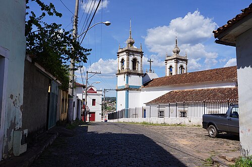
Igreja Matriz de Nossa Senhora da Boa Viagem
Church · Bairro Boa Viagem
18th-century colonial mother church, tied to the parish that gave rise to the town.
Complexo Turístico da Estação
Railway station · Praça Dr. Guilherme, Centro
Old 1887 station, restored and reopened in 2003. It houses a library, tourist information and the Sala dos Ferroviários.
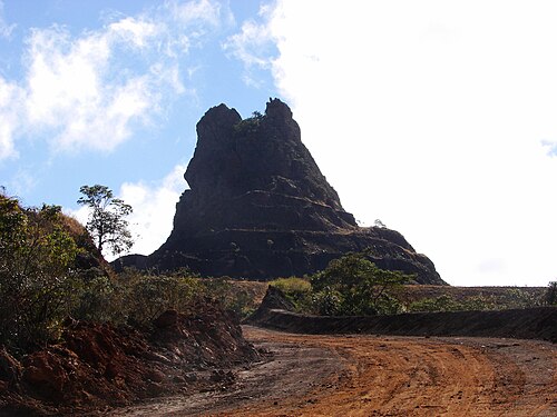
Pico do Itabirito
Nature · Rural area
A 1,586 m hematite monolith, the symbol of the town. Visits are restricted and require authorization from the mining company.
Alto do Cristo
Lookout · Morro do Cristo
Lookout at 1,179 m, with a statue of Christ and views of the Serra da Piedade, Itacolomi and Caraça.
Capela de Nossa Senhora do Rosário
Church · Rua do Rosário
Chapel at the top of Rua do Rosário, among the town's historic landmarks.
Capela do Senhor Bom Jesus de Matozinhos
Church · Rua do Matozinhos
Chapel at the top of Rua do Matozinhos, in the historic center.
Capela de Nossa Senhora das Mercês
Church · Rua do Matozinhos
Small chapel dating from 1836.
Mercearia Paraopeba
Market · Town center
General store founded in 1895, with iron pots, cheeses, sweets and a stamp for the Estrada Real passport.
Parque Ecológico Municipal
Park
Park with free admission, a lake and a mini zoo.
Serra da Santa
Lookout · BR-356, na chegada de BH
Right off the BR-356, it forms a sea of clouds on winter mornings.
Museu Jeca Tatu
Museum · BR-356, saída da cidade
Holds hundreds of old objects.
Estação Ecológica Estadual de Arêdes
Nature
Protected area managed by the Instituto Estadual de Florestas.
Heritage
- Pico do Itabirito · Natural monument protected by the Minas Gerais Constitution in 1989
- Igreja de Nossa Senhora do Rosário · Listed by IPHAN in 1955
- Railway Station Ensemble · Listed by the municipality, home of the tourist complex
- Angu pastry · Recognized as cultural heritage of the municipality
Nature
- Pico do Itabirito · A 1,586 m hematite monolith, the highest point in the municipality
- Estação Ecológica de Arêdes · State protected area
- Serra da Santa · Natural lookout famous for its sea of clouds in winter
Rivers and waters
- River basin: Rio São Francisco (Rio das Velhas sub-basin)
- Rivers: Rio Itabirito
Climate
- Type: Highland tropical (Cwb)
- Winter: Dry, with occasional frost
- Summer: Mild and humid
- Best time to visit: April to September, and July for Julifest
Typical food
- Angu pastry · The town's signature dish, with many fillings
- Chicken in blood sauce · Served at Julifest
- Banana blossom with angu and meat · A typical Julifest dish
- Feijão tropeiro (drover's beans) · Minas Gerais classic served at local festivals
Festivals and events
- Julifest (jul) · Four days at Praça dos Inconfidentes, in the second week of July, with Minas Gerais food and quentão (hot spiced cachaça)
- Festa do Pastel de Angu · Held since 2000, with tastings, quadrilhas (square dances) and music
Fun facts
- The name Itabirito is of Indigenous origin and, according to IBGE, means sharp stone.
- The Pico do Itabirito is an almost pure block of iron-rich hematite.
- The town is crossed by two railways: the old Central do Brasil and the Ferrovia do Aço.
- Dom Pedro II arrived in town by train, aboard a Maria Fumaça (steam locomotive).
- Until 1923 the territory was part of Ouro Preto.
Getting there
- Belo Horizonte · 57 km via BR-040 and BR-356
- Ouro Preto · 48 km via BR-356
Districts
- Acuruí
- Bação
- São Gonçalo do Monte
Notable people from Itabirito
- Telê Santana · Soccer player and coach, born in Itabirito
- Alyrio Cavallieri · Judge and appellate judge for Children and Adolescents, a native of the town
- Adriana Araújo · Journalist, a native of the town
- Elio da Mata · Physician born in Itabirito, elected mayor in 2024
People born in Itabirito
- Fernando Gomes Caldeira de Oliveira Fontoura · Brazilian politician
- Jorge Dikamba · Escritor, compositor e musicista brasileiro · b. 1972
- João d'Ávila Moreira Lima · Catholic priest, Catholic bishop, university professor · 1919–2011
- Luciano Jacques de Moraes · Brazilian engineer and geologist · 1896–1968
- Paulo Florencio · Brazilian footballer · 1918–2010
- Valcir da Silva · Comerciante e político brasileiro · b. 1962
City hall
- Mayor: Dr. Elio da Mata (Elio da Mata Santos) (Cidadania), term 2025–2028
- Address: Avenida Queiroz Júnior, 635, Itabirito, MG, CEP 35450-000
- Phone: (31) 3569-1000
- Website: www.itabirito.mg.gov.br
Frequently asked questions
Where is Itabirito?
Itabirito is a municipality in the state of Minas Gerais, Brazil, in the Greater BH and Central region, 57 km from Belo Horizonte.
What is there to do in Itabirito?
The attractions of Itabirito include Igreja Matriz de Nossa Senhora da Boa Viagem, Complexo Turístico da Estação, Pico do Itabirito, Alto do Cristo, Capela de Nossa Senhora do Rosário, Capela do Senhor Bom Jesus de Matozinhos.
What is the population of Itabirito?
Itabirito has about 53 thousand inhabitants in an area of 544 km².
What is the typical food of Itabirito?
Pastel de angu (The town's signature dish, with many fillings); Frango ao molho pardo (Served at Julifest); Umbigo de banana com angu e carne (A typical Julifest dish); Feijão tropeiro (Minas Gerais classic served at local festivals).
When is the best time to visit Itabirito?
April to September, and July for Julifest. The climate is highland tropical (cwb).
How do you get to Itabirito?
Belo Horizonte: 57 km via BR-040 and BR-356. Ouro Preto: 48 km via BR-356.
Who was born in Itabirito?
Notable people from Itabirito include Telê Santana, Alyrio Cavallieri, Adriana Araújo, Elio da Mata, Fernando Gomes Caldeira de Oliveira Fontoura (brazilian politician), Jorge Dikamba (brazilian writer, composer and musician), João d'Ávila Moreira Lima (catholic priest, catholic bishop, university professor), Luciano Jacques de Moraes (brazilian engineer and geologist).
Which tourism region is Itabirito part of?
Itabirito is part of IGR Ouro, one of the 47 official tourism regions of Minas Gerais, with 18 municipalities.
What are the festivals of Itabirito?
Julifest (jul), Festa do Pastel de Angu.
What are people from Itabirito called?
People born in Itabirito are called itabiritense.
Towns near Itabirito
- Rio Acima · 18 km in a straight line
- Moeda · 28 km in a straight line
- Congonhas · 28 km in a straight line
- Belo Vale · 29 km in a straight line
- Nova Lima · 31 km in a straight line
- Raposos · 32 km in a straight line
- Ouro Branco · 33 km in a straight line
- Ouro Preto · 34 km in a straight line